Bīr el Maksūr night lights from space
Night Light of Bīr el Maksūr (Northern District) from space (Israel) Src. Average luminocity for 10x10km area is 78.4283% and for 50x50km: 60.1134%.
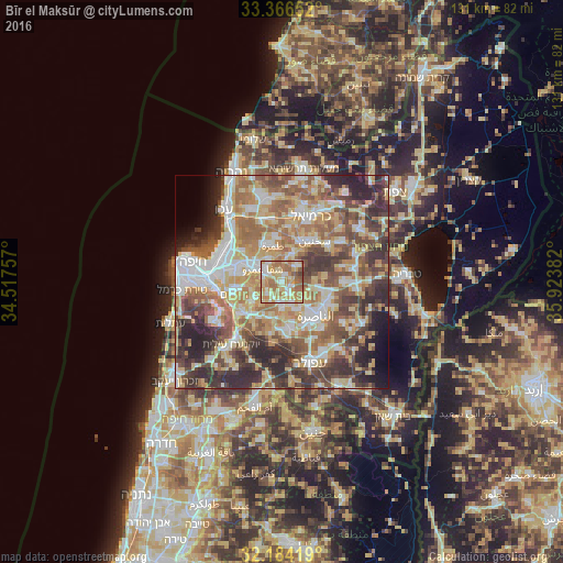
Analysis of Bīr el Maksūr night lights 2016
Square area 10x10 km:
 10.84%
90-99
15.03%80-89
24.13%70-79
19.06%60-69
21.85%50-59
7.17%40-49
1.75%30-39
0.17%20-29
0%10-19
0%0-9
0%Square area 50x50 km:
10.11%90-99
10.07%80-89
12.64%70-79
8.98%60-69
10.64%50-59
9.71%40-49
9.84%30-39
9.77%20-29
10.07%10-19
3.48%0-9
4.69%Clear (daylight) street map image can be seen on geolist.org.
Map coordinates:
33° 21' 59.5" North, 34° 31' 3.3" East
32° 46' 38.4" North, 35° 13' 14.5" East
32° 11' 3.1" North, 35° 55' 25.8" East
Some cities around Bīr el Maksūr sort by population:
• Nazareth
11.1 km =6.9 mi,  140°
140°
• Qiryat Ata
10.7 km =6.6 mi,  290°
290°
• Tamra
8.7 km =5.4 mi,  346°
346°
• Er Reina
10.8 km =6.7 mi,  123°
123°
• Kafr Mandā
5.2 km =3.2 mi,  45°
45°
• Kābūl
10.2 km =6.3 mi,  355°
355°
• Basmat Ṭab‘ūn
7.3 km =4.5 mi,  234°
234°
• Ramat Yishay
9.4 km =5.8 mi,  209°
209°
295404 (p: 7,106)
Sources (retrieved 2019-11-25):
» Earth at Night: Flat Maps 2012, 2016