Lovina night lights from space
Night Light of Lovina (Bali) from space (Indonesia) Src. Average luminocity for 10x10km area is 24.5372% and for 50x50km: 4.3117%.
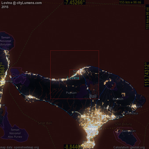
Analysis of Lovina night lights 2016
Square area 10x10 km:
100  1.03%
1.03%
90-99 5.37%
80-89 1.86%
70-79 6.2%
60-69 1.24%
50-59 2.69%
40-49 3.1%
30-39 4.96%
20-29 2.48%
10-19 27.27%
0-9 43.8%
1.03%90-99
5.37%80-89
1.86%70-79
6.2%60-69
1.24%50-59
2.69%40-49
3.1%30-39
4.96%20-29
2.48%10-19
27.27%0-9
43.8%Square area 50x50 km:
100 0.15%
90-99 0.9%
80-89 0.51%
70-79 0.5%
60-69 0.23%
50-59 0.52%
40-49 0.89%
30-39 0.72%
20-29 0.85%
10-19 3.34%
0-9 91.39%
0.15%90-99
0.9%80-89
0.51%70-79
0.5%60-69
0.23%50-59
0.52%40-49
0.89%30-39
0.72%20-29
0.85%10-19
3.34%0-9
91.39%Clear (daylight) street map image can be seen on geolist.org.
Map coordinates:
7° 27' 9.6" South, 114° 20' 12.7" East
8° 8' 57.4" South, 115° 2' 24" East
8° 50' 40.8" South, 115° 44' 35.2" East
Some cities around Lovina sort by population:
• Singaraja
6.7 km =4.2 mi,  52°
52°
• Banjar
9.2 km =5.7 mi,  240°
240°
• Tabanan
44.6 km =27.7 mi,  167°
167°
• Negara
52 km =32.3 mi, 243°
• Ubud
47.1 km =29.3 mi,  148°
148°
• Klungkung
58.2 km =36.2 mi,  137°
137°
• Seririt
12.1 km =7.5 mi,  246°
246°
• Munduk
14 km =8.7 mi,  161°
161°
8051286 (p: 10,000)
Sources (retrieved 2019-11-25):
» Earth at Night: Flat Maps 2012, 2016