Kaštel Lukšić night lights from space
Night Light of Kaštel Lukšić (Split-Dalmatia) from space (Croatia) Src. Average luminocity for 10x10km area is 29.973% and for 50x50km: 9.5718%.
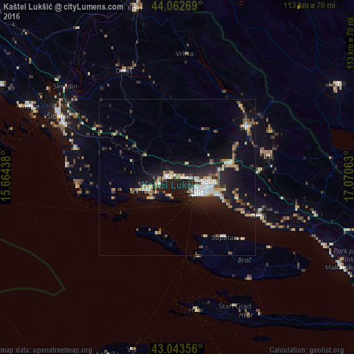
Analysis of Kaštel Lukšić night lights 2016
Square area 10x10 km:
 4.76%
4.76%90-99
5.71%80-89
1.9%70-79
3.17%60-69
2.22%50-59
3.65%40-49
2.54%30-39
2.7%20-29
9.84%10-19
51.59%0-9
11.9%Square area 50x50 km:
1.14%90-99
1.64%80-89
0.89%70-79
1.08%60-69
0.84%50-59
1.38%40-49
1.41%30-39
0.96%20-29
2.67%10-19
9.28%0-9
78.7%Clear (daylight) street map image can be seen on geolist.org.
Map coordinates:
44° 3' 45.7" North, 15° 39' 51.8" East
43° 33' 19" North, 16° 22' 3" East
43° 2' 36.8" North, 17° 4' 14.3" East
Some cities around Kaštel Lukšić sort by population:
• Split
7.7 km =4.8 mi,  131°
131°
• Šibenik
43 km =26.7 mi,  297°
297°
• Solin
10.2 km =6.3 mi,  97°
97°
• Sinj
27.4 km =17 mi,  52°
52°
• Trogir
10.5 km =6.5 mi,  243°
243°
• Podstrana
16.6 km =10.3 mi,  117°
117°
• Omiš
28.7 km =17.8 mi, 115°
• Vodice
52.3 km =32.5 mi, 295°
3198215 (p: 5,425)
Sources (retrieved 2019-11-25):
» Earth at Night: Flat Maps 2012, 2016