Agat Village night lights from space
Night Light of Agat Village (Agat) from space (Guam) Src. Average luminocity for 10x10km area is 29.2355% and for 50x50km: 9.0258%.
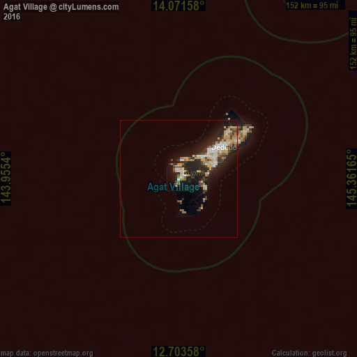
Analysis of Agat Village night lights 2016
Square area 10x10 km:
 4.55%
4.55%90-99
4.75%80-89
4.34%70-79
2.07%60-69
4.96%50-59
4.34%40-49
2.27%30-39
3.31%20-29
5.99%10-19
27.89%0-9
35.54%Square area 50x50 km:
1.28%90-99
1.2%80-89
1.36%70-79
1.36%60-69
1.01%50-59
0.82%40-49
1.06%30-39
1.73%20-29
3.3%10-19
6.58%0-9
80.3%Clear (daylight) street map image can be seen on geolist.org.
Map coordinates:
14° 4' 17.7" North, 143° 57' 19.4" East
13° 23' 18.8" North, 144° 39' 30.7" East
12° 42' 12.9" North, 145° 21' 41.9" East
Some cities around Agat Village sort by population:
• Santa Rita Village
1.5 km =0.9 mi,  100°
100°
• Chalan Pago-Ordot Village
12.7 km =7.9 mi,  58°
58°
• Yona Village
13 km =8.1 mi,  79°
79°
• Agana Heights Village
12.9 km =8 mi,  48°
48°
• Talofofo Village
11.4 km =7.1 mi,  108°
108°
• Asan-Maina Village
11.2 km =7 mi,  34°
34°
• Piti Village
9 km =5.6 mi,  24°
24°
• Umatac Village
10 km =6.2 mi,  177°
177°
4043804 (p: 5,656)
Sources (retrieved 2019-11-25):
» Earth at Night: Flat Maps 2012, 2016