Néa Moudhaniá night lights from space
Night Light of Néa Moudhaniá (Central Macedonia) from space (Greece) Src. Average luminocity for 10x10km area is 17.5584% and for 50x50km: 4.3455%.
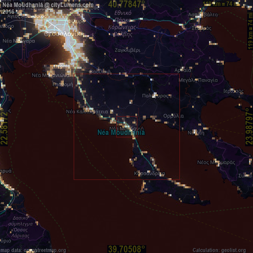
Analysis of Néa Moudhaniá night lights 2016
Square area 10x10 km:
 0.65%
0.65%90-99
1.46%80-89
1.62%70-79
1.3%60-69
3.9%50-59
4.06%40-49
0.65%30-39
4.87%20-29
6.17%10-19
7.79%0-9
67.53%Square area 50x50 km:
0.11%90-99
0.6%80-89
0.33%70-79
0.33%60-69
0.78%50-59
0.73%40-49
0.74%30-39
1.25%20-29
1.23%10-19
1.36%0-9
92.55%Clear (daylight) street map image can be seen on geolist.org.
Map coordinates:
40° 46' 42.5" North, 22° 34' 54.2" East
40° 14' 38" North, 23° 17' 5.4" East
39° 42' 18.3" North, 23° 59' 16.7" East
Some cities around Néa Moudhaniá sort by population:
• Peraía
41.5 km =25.8 mi,  313°
313°
• Thérmi
40.5 km =25.2 mi,  326°
326°
• Polýgyros
19.9 km =12.4 mi,  41°
41°
• Epanomí
36.4 km =22.6 mi,  303°
303°
• Néa Kallikráteia
20.3 km =12.6 mi,  292°
292°
• Trílofos
36.5 km =22.7 mi, 313°
• Plagiári
37.6 km =23.4 mi, 312°
• Néoi Epivátes
42.4 km =26.3 mi, 311°
734999 (p: 9,342)
Sources (retrieved 2019-11-25):
» Earth at Night: Flat Maps 2012, 2016