Kyparissía night lights from space
Night Light of Kyparissía (Peloponnese) from space (Greece) Src. Average luminocity for 10x10km area is 8.9932% and for 50x50km: 1.9398%.
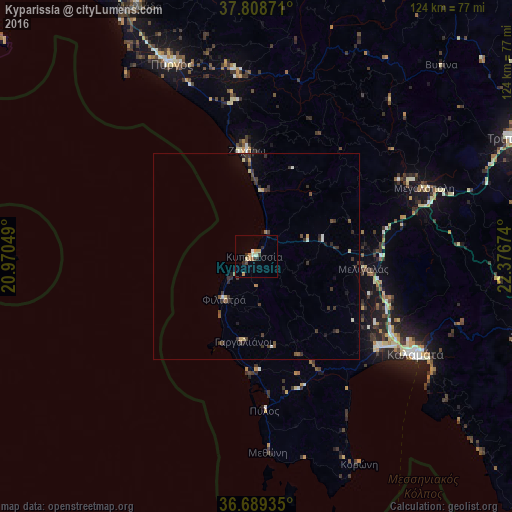
Analysis of Kyparissía night lights 2016
Square area 10x10 km:
 0%
0%90-99
2.04%80-89
0.68%70-79
2.89%60-69
0.51%50-59
1.02%40-49
0.85%30-39
1.53%20-29
1.7%10-19
0.34%0-9
88.44%Square area 50x50 km:
0.01%90-99
0.3%80-89
0.18%70-79
0.24%60-69
0.09%50-59
0.29%40-49
0.34%30-39
0.99%20-29
0.39%10-19
0.35%0-9
96.8%Clear (daylight) street map image can be seen on geolist.org.
Map coordinates:
37° 48' 31.4" North, 20° 58' 13.8" East
37° 15' 4" North, 21° 40' 25" East
36° 41' 21.7" North, 22° 22' 36.3" East
Some cities around Kyparissía sort by population:
• Kalamata
45.5 km =28.3 mi,  121°
121°
• Pýrgos
51.4 km =31.9 mi,  336°
336°
• Amaliáda
67.2 km =41.8 mi,  334°
334°
• Filiatrá
13.1 km =8.1 mi,  216°
216°
• Messíni
37 km =23 mi,  126°
126°
• Gargaliánoi
20.9 km =13 mi,  188°
188°
• Zacháro
25.9 km =16.1 mi,  355°
355°
• Megalópoli
44.7 km =27.8 mi,  68°
68°
259782 (p: 5,033)
Sources (retrieved 2019-11-25):
» Earth at Night: Flat Maps 2012, 2016