Káto Achaḯa night lights from space
Night Light of Káto Achaḯa (West Greece) from space (Greece) Src. Average luminocity for 10x10km area is 26.1633% and for 50x50km: 11.5839%.
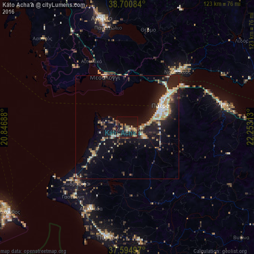
Analysis of Káto Achaḯa night lights 2016
Square area 10x10 km:
 0%
0%90-99
3.06%80-89
2.38%70-79
3.91%60-69
7.31%50-59
3.91%40-49
2.55%30-39
5.78%20-29
5.78%10-19
39.46%0-9
25.85%Square area 50x50 km:
0.84%90-99
2.03%80-89
1.47%70-79
1.25%60-69
1.71%50-59
1.14%40-49
1.1%30-39
2.36%20-29
4.19%10-19
10.63%0-9
73.29%Clear (daylight) street map image can be seen on geolist.org.
Map coordinates:
38° 42' 3" North, 20° 50' 48.8" East
38° 9' 0" North, 21° 33' 0" East
37° 35' 41.9" North, 22° 15' 11.3" East
Some cities around Káto Achaḯa sort by population:
• Pátra
19.2 km =11.9 mi,  56°
56°
• Aígio
47.8 km =29.7 mi,  76°
76°
• Amaliáda
42.8 km =26.6 mi,  204°
204°
• Náfpaktos
36.2 km =22.5 mi,  42°
42°
• Mesolóngi
26.7 km =16.6 mi,  337°
337°
• Gastoúni
42.5 km =26.4 mi,  218°
218°
• Paralía
14.4 km =8.9 mi,  68°
68°
• Ovriá
16.2 km =10.1 mi, 74°
260644 (p: 5,752)
Sources (retrieved 2019-11-25):
» Earth at Night: Flat Maps 2012, 2016