Baillif night lights from space
Night Light of Baillif (Guadeloupe) from space (Guadeloupe) Src. Average luminocity for 10x10km area is 27.3698% and for 50x50km: 7.0856%.
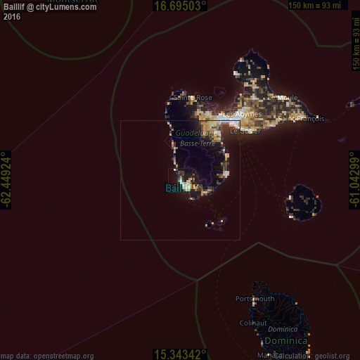
Analysis of Baillif night lights 2016
Square area 10x10 km:
 5.99%
5.99%90-99
4.34%80-89
3.72%70-79
3.51%60-69
3.1%50-59
0.83%40-49
2.27%30-39
4.34%20-29
4.34%10-19
23.76%0-9
43.8%Square area 50x50 km:
0.75%90-99
0.7%80-89
0.88%70-79
1.48%60-69
0.83%50-59
0.5%40-49
1.07%30-39
1.69%20-29
1.92%10-19
4.65%0-9
85.54%Clear (daylight) street map image can be seen on geolist.org.
Map coordinates:
16° 41' 42.1" North, 62° 26' 57.3" West
16° 1' 13.3" North, 61° 44' 46" West
15° 20' 36.3" North, 61° 2' 34.8" West
Some cities around Baillif sort by population:
• Capesterre-Belle-Eau
19.6 km =12.2 mi,  81°
81°
• Basse-Terre
3 km =1.9 mi,  149°
149°
• Saint-Claude
5 km =3.1 mi, 83°
• Trois-Rivières
11.9 km =7.4 mi,  114°
114°
• Gourbeyre
6.5 km =4 mi,  116°
116°
• Pointe-Noire
24 km =14.9 mi,  348°
348°
• Vieux-Habitants
4.8 km =3 mi,  332°
332°
• Bouillante
12.5 km =7.8 mi, 348°
3579761 (p: 5,705)
Sources (retrieved 2019-11-25):
» Earth at Night: Flat Maps 2012, 2016