Vigneux-de-Bretagne night lights from space
Night Light of Vigneux-de-Bretagne (Pays de la Loire) from space (France) Src. Average luminocity for 10x10km area is 9.2128% and for 50x50km: 14.4807%.
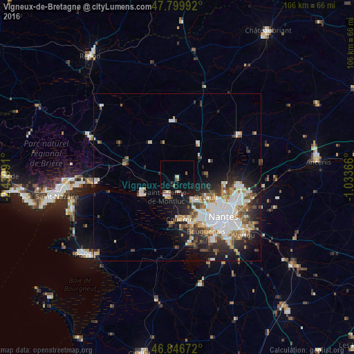
Analysis of Vigneux-de-Bretagne night lights 2016
Square area 10x10 km:
 0.89%
0.89%90-99
0.89%80-89
0.6%70-79
1.04%60-69
1.64%50-59
1.64%40-49
1.04%30-39
0%20-29
0.6%10-19
6.99%0-9
84.67%Square area 50x50 km:
3.86%90-99
2.88%80-89
1.15%70-79
1.37%60-69
1.67%50-59
1.65%40-49
1.67%30-39
1.63%20-29
3.54%10-19
6.44%0-9
74.13%Clear (daylight) street map image can be seen on geolist.org.
Map coordinates:
47° 47' 59.7" North, 2° 26' 23.7" West
47° 19' 31.7" North, 1° 44' 12.4" West
46° 50' 48.2" North, 1° 2' 1.2" West
Some cities around Vigneux-de-Bretagne sort by population:
• Saint-Herblain
13.7 km =8.5 mi,  150°
150°
• Orvault
10.6 km =6.6 mi,  124°
124°
• Couëron
12.3 km =7.6 mi,  174°
174°
• La Chapelle-sur-Erdre
14.2 km =8.8 mi,  103°
103°
• Sautron
8.6 km =5.3 mi,  144°
144°
• Saint-Étienne-de-Montluc
6.3 km =3.9 mi,  211°
211°
• Treillières
8.9 km =5.5 mi,  86°
86°
• Sucé-sur-Erdre
15.4 km =9.6 mi, 86°
2969111 (p: 5,095)
Sources (retrieved 2019-11-25):
» Earth at Night: Flat Maps 2012, 2016