Sénas night lights from space
Night Light of Sénas (Provence-Alpes-Côte d'Azur) from space (France) Src. Average luminocity for 10x10km area is 14.3121% and for 50x50km: 18.2262%.
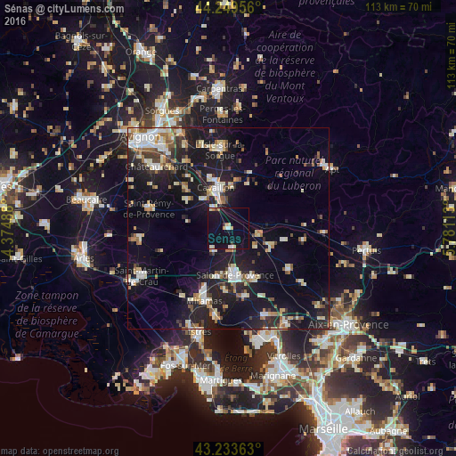
Analysis of Sénas night lights 2016
Square area 10x10 km:
 0.91%
0.91%90-99
2.42%80-89
1.82%70-79
2.27%60-69
1.06%50-59
0%40-49
0.61%30-39
1.21%20-29
0%10-19
21.21%0-9
68.48%Square area 50x50 km:
2.27%90-99
3.48%80-89
2.19%70-79
1.8%60-69
1.94%50-59
1.93%40-49
1.89%30-39
2.11%20-29
5.55%10-19
18.66%0-9
58.17%Clear (daylight) street map image can be seen on geolist.org.
Map coordinates:
44° 14' 58.4" North, 4° 22' 29.6" East
43° 44' 37.5" North, 5° 4' 40.8" East
43° 14' 1.1" North, 5° 46' 52.1" East
Some cities around Sénas sort by population:
• Salon-de-Provence
11.4 km =7.1 mi,  173°
173°
• Cavaillon
10.3 km =6.4 mi,  340°
340°
• Miramas
18.7 km =11.6 mi,  198°
198°
• Pélissanne
13.7 km =8.5 mi,  154°
154°
• Lambesc
17.9 km =11.1 mi,  124°
124°
• Lançon-Provence
17.3 km =10.7 mi, 166°
• Eyguières
6.6 km =4.1 mi,  214°
214°
• Mallemort
8.3 km =5.2 mi,  99°
99°
2975120 (p: 6,062)
Sources (retrieved 2019-11-25):
» Earth at Night: Flat Maps 2012, 2016