Sarrebourg night lights from space
Night Light of Sarrebourg (Grand Est) from space (France) Src. Average luminocity for 10x10km area is 22.2247% and for 50x50km: 3.2966%.
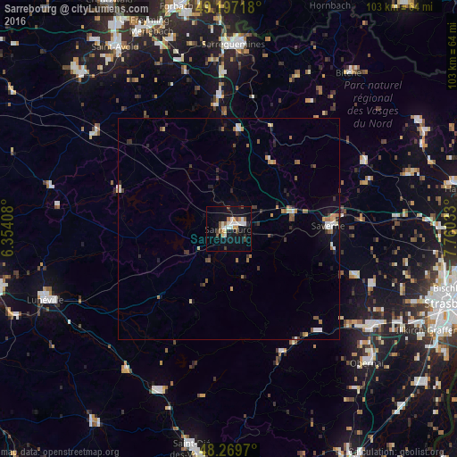
Analysis of Sarrebourg night lights 2016
Square area 10x10 km:
 4.91%
4.91%90-99
3.57%80-89
1.64%70-79
2.38%60-69
2.08%50-59
2.68%40-49
2.68%30-39
1.34%20-29
0.74%10-19
26.93%0-9
51.04%Square area 50x50 km:
0.42%90-99
0.38%80-89
0.31%70-79
0.38%60-69
0.53%50-59
0.44%40-49
0.39%30-39
0.48%20-29
0.57%10-19
1.82%0-9
94.29%Clear (daylight) street map image can be seen on geolist.org.
Map coordinates:
49° 11' 49.8" North, 6° 21' 14.7" East
48° 44' 8.1" North, 7° 3' 25.9" East
48° 16' 10.9" North, 7° 45' 37.2" East
Some cities around Sarrebourg sort by population:
• Lunéville
44.3 km =27.5 mi,  248°
248°
• Saverne
22.4 km =13.9 mi,  88°
88°
• Obernai
43.5 km =27 mi,  134°
134°
• Molsheim
38.6 km =24 mi,  124°
124°
• Farébersviller
44.8 km =27.8 mi,  342°
342°
• Mutzig
36.5 km =22.7 mi, 126°
• Wasselonne
30.5 km =19 mi,  110°
110°
• Bitche
44.5 km =27.7 mi,  37°
37°
2975967 (p: 14,677)
Sources (retrieved 2019-11-25):
» Earth at Night: Flat Maps 2012, 2016