Salies-de-Béarn night lights from space
Night Light of Salies-de-Béarn (Nouvelle-Aquitaine) from space (France) Src. Average luminocity for 10x10km area is 2.3254% and for 50x50km: 1.8387%.
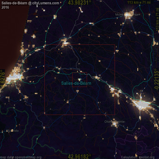
Analysis of Salies-de-Béarn night lights 2016
Square area 10x10 km:
 0%
0%90-99
0.63%80-89
0%70-79
1.11%60-69
0.16%50-59
0.32%40-49
0.32%30-39
0%20-29
0%10-19
0.63%0-9
96.83%Square area 50x50 km:
0.1%90-99
0.15%80-89
0.13%70-79
0.25%60-69
0.38%50-59
0.44%40-49
0.32%30-39
0.25%20-29
0.59%10-19
1.01%0-9
96.38%Clear (daylight) street map image can be seen on geolist.org.
Map coordinates:
43° 58' 56.3" North, 1° 37' 39.4" West
43° 28' 27.2" North, 0° 55' 28.1" West
42° 57' 42.6" North, 0° 13' 16.9" West
Some cities around Salies-de-Béarn sort by population:
• Dax
28.2 km =17.5 mi,  338°
338°
• Oloron-Sainte-Marie
40.1 km =24.9 mi,  140°
140°
• Orthez
12.4 km =7.7 mi,  82°
82°
• Saint-Paul-lès-Dax
29.9 km =18.6 mi, 339°
• Mourenx
28.1 km =17.5 mi,  111°
111°
• Hasparren
32.3 km =20.1 mi,  251°
251°
• Saint-Vincent-de-Tyrosse
37.2 km =23.1 mi,  303°
303°
• Ustaritz
43.8 km =27.2 mi,  258°
258°
2976444 (p: 5,235)
Sources (retrieved 2019-11-25):
» Earth at Night: Flat Maps 2012, 2016