Pontcharra night lights from space
Night Light of Pontcharra (Auvergne-Rhône-Alpes) from space (France) Src. Average luminocity for 10x10km area is 12.0413% and for 50x50km: 7.8532%.
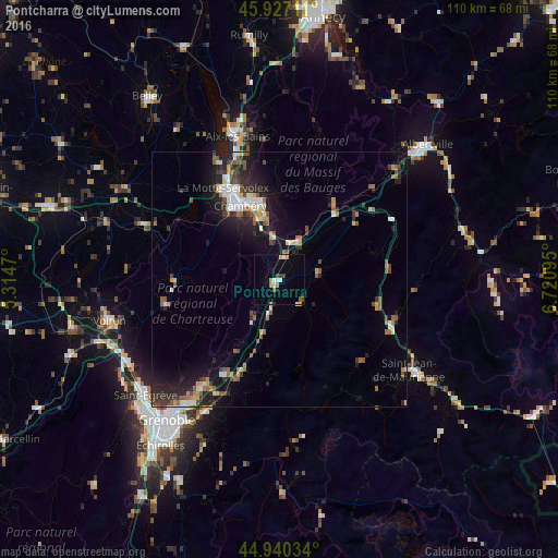
Analysis of Pontcharra night lights 2016
Square area 10x10 km:
 0.95%
0.95%90-99
1.9%80-89
1.27%70-79
1.75%60-69
1.43%50-59
1.27%40-49
1.11%30-39
1.11%20-29
0.32%10-19
3.02%0-9
85.87%Square area 50x50 km:
0.83%90-99
1.29%80-89
0.64%70-79
0.73%60-69
1.01%50-59
1.46%40-49
0.99%30-39
1.21%20-29
2.6%10-19
5.31%0-9
83.93%Clear (daylight) street map image can be seen on geolist.org.
Map coordinates:
45° 55' 37.6" North, 5° 18' 52.9" East
45° 26' 9.2" North, 6° 1' 4.2" East
44° 56' 25.2" North, 6° 43' 15.4" East
Some cities around Pontcharra sort by population:
• Chambéry
16.4 km =10.2 mi,  332°
332°
• La Motte-Servolex
21.4 km =13.3 mi, 326°
• Crolles
20.7 km =12.9 mi,  211°
211°
• Villard-Bonnot
24.7 km =15.3 mi, 205°
• La Ravoire
14.8 km =9.2 mi,  341°
341°
• Cognin
16.9 km =10.5 mi,  324°
324°
• Saint-Alban-Leysse
17.2 km =10.7 mi, 342°
• Barberaz
15.2 km =9.4 mi, 337°
2986275 (p: 6,948)
Sources (retrieved 2019-11-25):
» Earth at Night: Flat Maps 2012, 2016