Nérac night lights from space
Night Light of Nérac (Nouvelle-Aquitaine) from space (France) Src. Average luminocity for 10x10km area is 5.5955% and for 50x50km: 3.1054%.
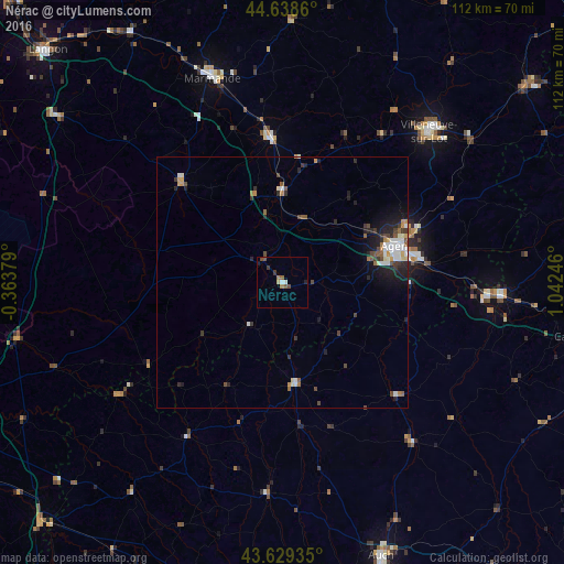
Analysis of Nérac night lights 2016
Square area 10x10 km:
 0.45%
0.45%90-99
0.76%80-89
0.61%70-79
0%60-69
1.36%50-59
1.21%40-49
1.67%30-39
1.21%20-29
0.3%10-19
0.91%0-9
91.52%Square area 50x50 km:
0.45%90-99
0.57%80-89
0.2%70-79
0.36%60-69
0.28%50-59
0.44%40-49
0.55%30-39
0.56%20-29
0.92%10-19
1.69%0-9
93.96%Clear (daylight) street map image can be seen on geolist.org.
Map coordinates:
44° 38' 19" North, 0° 21' 49.6" West
44° 8' 10.1" North, 0° 20' 21.6" East
43° 37' 45.7" North, 1° 2' 32.9" East
Some cities around Nérac sort by population:
• Agen
24 km =14.9 mi,  72°
72°
• Tonneins
28.5 km =17.7 mi,  355°
355°
• Le Passage
22.2 km =13.8 mi, 70°
• Condom
20 km =12.4 mi,  172°
172°
• Sainte-Livrade-sur-Lot
35.5 km =22.1 mi,  34°
34°
• Bon-Encontre
26.7 km =16.6 mi,  78°
78°
• Casteljaloux
28.5 km =17.7 mi,  314°
314°
• Foulayronnes
27 km =16.8 mi,  64°
64°
2990780 (p: 7,688)
Sources (retrieved 2019-11-25):
» Earth at Night: Flat Maps 2012, 2016