Montlhéry night lights from space
Night Light of Montlhéry (Île-de-France) from space (France) Src. Average luminocity for 10x10km area is 80.3676% and for 50x50km: 50.2648%.
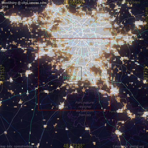
Analysis of Montlhéry night lights 2016
Square area 10x10 km:
 24.11%
90-99
22.17%80-89
9.52%70-79
14.43%60-69
13.39%50-59
6.1%40-49
4.76%30-39
4.61%20-29
0.89%10-19
0%0-9
0%Square area 50x50 km:
20.21%90-99
12.91%80-89
3.75%70-79
4.1%60-69
4.65%50-59
3.5%40-49
4.88%30-39
4.51%20-29
4.59%10-19
6.32%0-9
30.58%Clear (daylight) street map image can be seen on geolist.org.
Map coordinates:
49° 6' 9.1" North, 1° 34' 17.5" East
48° 38' 24.1" North, 2° 16' 28.7" East
48° 10' 23.8" North, 2° 58' 40" East
Some cities around Montlhéry sort by population:
• Sainte-Geneviève-des-Bois
3.4 km =2.1 mi,  77°
77°
• Brétigny-sur-Orge
3.9 km =2.4 mi,  144°
144°
• Saint-Michel-sur-Orge
2.5 km =1.6 mi,  103°
103°
• Épinay-sur-Orge
4.6 km =2.9 mi,  35°
35°
• Marcoussis
2.7 km =1.7 mi,  270°
270°
• La Ville-du-Bois
1.7 km =1.1 mi,  344°
344°
• Longpont-sur-Orge
1.3 km =0.8 mi, 82°
• Linas
1.4 km =0.9 mi,  219°
219°
2992309 (p: 6,351)
Sources (retrieved 2019-11-25):
» Earth at Night: Flat Maps 2012, 2016