Linas night lights from space
Night Light of Linas (Île-de-France) from space (France) Src. Average luminocity for 10x10km area is 76.2515% and for 50x50km: 47.3972%.
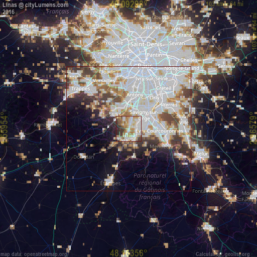
Analysis of Linas night lights 2016
Square area 10x10 km:
 20.98%
90-99
21.28%80-89
9.38%70-79
13.69%60-69
10.27%50-59
6.1%40-49
6.25%30-39
6.4%20-29
5.65%10-19
0%0-9
0%Square area 50x50 km:
18.76%90-99
12.25%80-89
3.58%70-79
3.85%60-69
4.52%50-59
3.28%40-49
4.54%30-39
4.22%20-29
4.37%10-19
6.46%0-9
34.16%Clear (daylight) street map image can be seen on geolist.org.
Map coordinates:
49° 5' 34.7" North, 1° 33' 34.3" East
48° 37' 49.5" North, 2° 15' 45.6" East
48° 9' 48.8" North, 2° 57' 56.8" East
Some cities around Linas sort by population:
• Sainte-Geneviève-des-Bois
4.6 km =2.9 mi,  66°
66°
• Brétigny-sur-Orge
3.8 km =2.4 mi,  123°
123°
• Saint-Michel-sur-Orge
3.4 km =2.1 mi,  81°
81°
• Saint-Germain-lès-Arpajon
3.7 km =2.3 mi,  177°
177°
• Marcoussis
2.1 km =1.3 mi,  301°
301°
• Montlhéry
1.4 km =0.9 mi,  39°
39°
• La Ville-du-Bois
2.8 km =1.7 mi,  8°
8°
• Longpont-sur-Orge
2.5 km =1.6 mi,  60°
60°
2998251 (p: 6,050)
Sources (retrieved 2019-11-25):
» Earth at Night: Flat Maps 2012, 2016