Martignas-sur-Jalle night lights from space
Night Light of Martignas-sur-Jalle (Nouvelle-Aquitaine) from space (France) Src. Average luminocity for 10x10km area is 37.5651% and for 50x50km: 24.3529%.
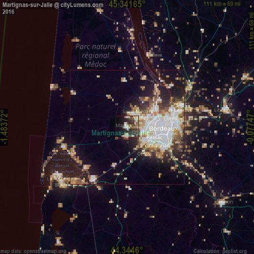
Analysis of Martignas-sur-Jalle night lights 2016
Square area 10x10 km:
 3.97%
3.97%90-99
7.78%80-89
5.56%70-79
3.02%60-69
3.33%50-59
5.71%40-49
6.35%30-39
12.86%20-29
13.65%10-19
17.46%0-9
20.32%Square area 50x50 km:
6.02%90-99
4.77%80-89
2.44%70-79
2.49%60-69
3.23%50-59
2.91%40-49
3.07%30-39
3.06%20-29
4.29%10-19
11.84%0-9
55.88%Clear (daylight) street map image can be seen on geolist.org.
Map coordinates:
45° 20' 29.9" North, 1° 29' 1.4" West
44° 50' 43" North, 0° 46' 50.2" West
44° 20' 40.6" North, 0° 4' 38.9" West
Some cities around Martignas-sur-Jalle sort by population:
• Mérignac
11.7 km =7.3 mi,  97°
97°
• Pessac
11.7 km =7.3 mi,  109°
109°
• Saint-Médard-en-Jalles
7.4 km =4.6 mi,  39°
39°
• Eysines
11.4 km =7.1 mi,  68°
68°
• Le Haillan
8.5 km =5.3 mi, 69°
• Le Taillan-Médoc
10.9 km =6.8 mi,  52°
52°
• Saint-Jean-d’Illac
4.1 km =2.5 mi,  185°
185°
• Saint-Aubin-de-Médoc
8.6 km =5.3 mi,  30°
30°
2995404 (p: 6,803)
Sources (retrieved 2019-11-25):
» Earth at Night: Flat Maps 2012, 2016