Marseille Saint-Victor night lights from space
Night Light of Marseille Saint-Victor (Provence-Alpes-Côte d'Azur) from space (France) Src. Average luminocity for 10x10km area is 71.7864% and for 50x50km: 27.8917%.
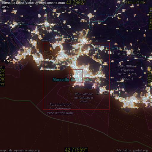
Analysis of Marseille Saint-Victor night lights 2016
Square area 10x10 km:
 46.52%
90-99
14.24%80-89
0.91%70-79
1.36%60-69
0.45%50-59
1.21%40-49
2.27%30-39
8.79%20-29
12.42%10-19
9.7%0-9
2.12%Square area 50x50 km:
6.31%90-99
6.07%80-89
2.77%70-79
2.11%60-69
2.75%50-59
2.98%40-49
3.16%30-39
5.32%20-29
10.29%10-19
14.44%0-9
43.81%Clear (daylight) street map image can be seen on geolist.org.
Map coordinates:
43° 47' 57.1" North, 4° 39' 55.2" East
43° 17' 22.4" North, 5° 22' 6.4" East
42° 46' 32.1" North, 6° 4' 17.7" East
Some cities around Marseille Saint-Victor sort by population:
• Saint-Lambert
0.8 km =0.5 mi,  240°
240°
• Belsunce
1.2 km =0.7 mi,  34°
34°
• Les Grands Carmes
1.3 km =0.8 mi,  16°
16°
• Castellane
1.2 km =0.7 mi,  109°
109°
• Notre-Dame du Mont
1.2 km =0.7 mi,  71°
71°
• Le Pharo
0.8 km =0.5 mi,  284°
284°
• Palais de Justice
0.7 km =0.4 mi,  118°
118°
• Thiers
1.4 km =0.9 mi,  51°
51°
9609487 (p: 6,926)
Sources (retrieved 2019-11-25):
» Earth at Night: Flat Maps 2012, 2016