Les Olives night lights from space
Night Light of Les Olives (Provence-Alpes-Côte d'Azur) from space (France) Src. Average luminocity for 10x10km area is 84.4106% and for 50x50km: 30.2934%.
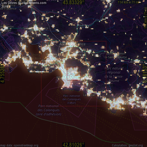
Analysis of Les Olives night lights 2016
Square area 10x10 km:
 40.61%
90-99
27.73%80-89
3.64%70-79
2.88%60-69
6.82%50-59
5.61%40-49
3.03%30-39
5.15%20-29
4.39%10-19
0.15%0-9
0%Square area 50x50 km:
6.75%90-99
6.61%80-89
3.13%70-79
2.46%60-69
2.94%50-59
3.22%40-49
3.5%30-39
5.65%20-29
10.68%10-19
14.88%0-9
40.17%Clear (daylight) street map image can be seen on geolist.org.
Map coordinates:
43° 49' 59.8" North, 4° 45' 19" East
43° 19' 26.1" North, 5° 27' 30.2" East
42° 48' 36.9" North, 6° 9' 41.5" East
Some cities around Les Olives sort by population:
• Allauch
2.3 km =1.4 mi,  55°
55°
• La Rose
2.5 km =1.6 mi,  282°
282°
• Montolivet
2.9 km =1.8 mi,  255°
255°
• Plan-de-Cuques
2.7 km =1.7 mi,  9°
9°
• Saint-Julien
1.4 km =0.9 mi,  211°
211°
• Les Caillols
2.6 km =1.6 mi,  199°
199°
• La Croix-Rouge
1.1 km =0.7 mi,  341°
341°
• Les Trois-Lucs
1.2 km =0.7 mi,  163°
163°
3000138 (p: 15,181)
Sources (retrieved 2019-11-25):
» Earth at Night: Flat Maps 2012, 2016