L’Isle-Jourdain night lights from space
Night Light of L’Isle-Jourdain (Occitanie) from space (France) Src. Average luminocity for 10x10km area is 5.8955% and for 50x50km: 11.8584%.
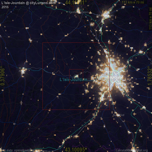
Analysis of L’Isle-Jourdain night lights 2016
Square area 10x10 km:
 0.91%
0.91%90-99
0.3%80-89
0.76%70-79
0.45%60-69
1.21%50-59
0%40-49
1.21%30-39
1.97%20-29
1.67%10-19
0.91%0-9
90.61%Square area 50x50 km:
1.65%90-99
2.14%80-89
1.55%70-79
1.56%60-69
1.8%50-59
1.83%40-49
1.75%30-39
2%20-29
2.98%10-19
5.39%0-9
77.38%Clear (daylight) street map image can be seen on geolist.org.
Map coordinates:
44° 7' 8.8" North, 0° 22' 44.6" East
43° 36' 43.8" North, 1° 4' 55.9" East
43° 6' 3.4" North, 1° 47' 7.2" East
Some cities around L’Isle-Jourdain sort by population:
• Tournefeuille
19.3 km =12 mi,  97°
97°
• Plaisance-du-Touch
18.1 km =11.2 mi,  106°
106°
• Pibrac
16.4 km =10.2 mi,  86°
86°
• Fonsorbes
14.6 km =9.1 mi,  125°
125°
• Léguevin
12.2 km =7.6 mi, 96°
• La Salvetat-Saint-Gilles
15.8 km =9.8 mi, 104°
• Saint-Lys
13.5 km =8.4 mi,  146°
146°
• Cornebarrieu
19.9 km =12.4 mi,  78°
78°
2998130 (p: 8,729)
Sources (retrieved 2019-11-25):
» Earth at Night: Flat Maps 2012, 2016