Fonsorbes night lights from space
Night Light of Fonsorbes (Occitanie) from space (France) Src. Average luminocity for 10x10km area is 23.7651% and for 50x50km: 21.9312%.
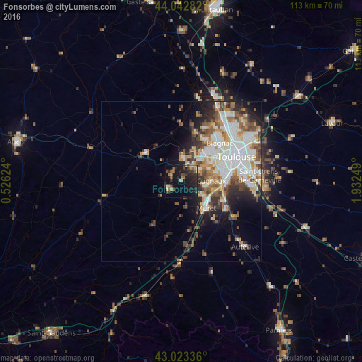
Analysis of Fonsorbes night lights 2016
Square area 10x10 km:
 0.48%
0.48%90-99
1.59%80-89
3.02%70-79
2.06%60-69
4.13%50-59
4.6%40-49
3.81%30-39
4.76%20-29
11.9%10-19
30.95%0-9
32.7%Square area 50x50 km:
4.92%90-99
5.01%80-89
2.39%70-79
2.23%60-69
2.75%50-59
2.84%40-49
3.09%30-39
2.8%20-29
4.48%10-19
6.41%0-9
63.08%Clear (daylight) street map image can be seen on geolist.org.
Map coordinates:
44° 2' 34.2" North, 0° 31' 34.5" East
43° 32' 6.9" North, 1° 13' 45.7" East
43° 1' 24.1" North, 1° 55' 57" East
Some cities around Fonsorbes sort by population:
• Plaisance-du-Touch
6.4 km =4 mi,  58°
58°
• Cugnaux
9.3 km =5.8 mi,  89°
89°
• Villeneuve-Tolosane
9.1 km =5.7 mi,  98°
98°
• Léguevin
7.2 km =4.5 mi,  1°
1°
• Seysses
7.8 km =4.8 mi,  122°
122°
• Frouzins
8.1 km =5 mi,  106°
106°
• La Salvetat-Saint-Gilles
5.7 km =3.5 mi,  36°
36°
• Saint-Lys
5.1 km =3.2 mi,  238°
238°
3018103 (p: 7,745)
Sources (retrieved 2019-11-25):
» Earth at Night: Flat Maps 2012, 2016