Castelsarrasin night lights from space
Night Light of Castelsarrasin (Occitanie) from space (France) Src. Average luminocity for 10x10km area is 12.4349% and for 50x50km: 5.2225%.
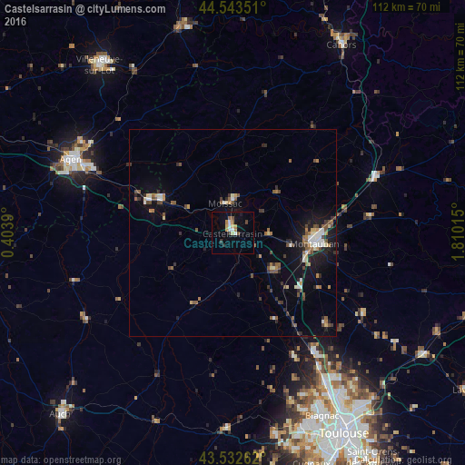
Analysis of Castelsarrasin night lights 2016
Square area 10x10 km:
 1.43%
1.43%90-99
1.75%80-89
1.27%70-79
1.9%60-69
1.75%50-59
1.43%40-49
1.27%30-39
1.27%20-29
0.63%10-19
6.51%0-9
80.79%Square area 50x50 km:
0.54%90-99
0.66%80-89
0.47%70-79
0.46%60-69
0.69%50-59
1%40-49
0.86%30-39
0.65%20-29
1.16%10-19
3.54%0-9
89.97%Clear (daylight) street map image can be seen on geolist.org.
Map coordinates:
44° 32' 36.6" North, 0° 24' 14" East
44° 2' 24.8" North, 1° 6' 25.3" East
43° 31' 57.4" North, 1° 48' 36.5" East
Some cities around Castelsarrasin sort by population:
• Montauban
20.7 km =12.9 mi,  96°
96°
• Moissac
7 km =4.3 mi,  351°
351°
• Fleurance
41.5 km =25.8 mi,  239°
239°
• Grenade
33.5 km =20.8 mi,  155°
155°
• Caussade
37 km =23 mi,  68°
68°
• Bon-Encontre
38.6 km =24 mi,  294°
294°
• Villemur-sur-Tarn
37.1 km =23.1 mi,  121°
121°
• Valence
18.8 km =11.7 mi, 293°
3028322 (p: 13,260)
Sources (retrieved 2019-11-25):
» Earth at Night: Flat Maps 2012, 2016