Chambly night lights from space
Night Light of Chambly (Hauts-de-France) from space (France) Src. Average luminocity for 10x10km area is 37.0882% and for 50x50km: 34.9826%.
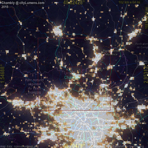
Analysis of Chambly night lights 2016
Square area 10x10 km:
 5.46%
5.46%90-99
6.02%80-89
4.76%70-79
4.06%60-69
4.9%50-59
3.36%40-49
4.48%30-39
7.7%20-29
14.57%10-19
35.15%0-9
9.52%Square area 50x50 km:
9.58%90-99
8.05%80-89
3.22%70-79
3.04%60-69
3.56%50-59
3.59%40-49
3.92%30-39
4.05%20-29
7.7%10-19
15.9%0-9
37.38%Clear (daylight) street map image can be seen on geolist.org.
Map coordinates:
49° 37' 27.4" North, 1° 32' 48.8" East
49° 10' 0" North, 2° 15' 0" East
48° 42' 17.2" North, 2° 57' 11.3" East
Some cities around Chambly sort by population:
• Méru
11.3 km =7 mi,  311°
311°
• L’Isle-Adam
6.8 km =4.2 mi,  193°
193°
• Gouvieux
12.2 km =7.6 mi,  79°
79°
• Méry-sur-Oise
12.7 km =7.9 mi,  199°
199°
• Persan
2.2 km =1.4 mi,  132°
132°
• Beaumont-sur-Oise
3.8 km =2.4 mi,  135°
135°
• Auvers-sur-Oise
12.1 km =7.5 mi,  208°
208°
• Parmain
6.5 km =4 mi, 202°
3027397 (p: 9,506)
Sources (retrieved 2019-11-25):
» Earth at Night: Flat Maps 2012, 2016