Pedersöre night lights from space
Night Light of Pedersöre (Ostrobothnia) from space (Finland) Src. Average luminocity for 10x10km area is 19.0294% and for 50x50km: 3.5091%.
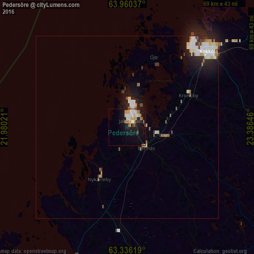
Analysis of Pedersöre night lights 2016
Square area 10x10 km:
 2.08%
2.08%90-99
4.83%80-89
2.18%70-79
3.03%60-69
2.37%50-59
2.46%40-49
1.14%30-39
0%20-29
2.37%10-19
19.6%0-9
59.94%Square area 50x50 km:
0.6%90-99
0.86%80-89
0.42%70-79
0.33%60-69
0.32%50-59
0.43%40-49
0.24%30-39
0.24%20-29
0.88%10-19
2.5%0-9
93.18%Clear (daylight) street map image can be seen on geolist.org.
Map coordinates:
63° 57' 37.3" North, 21° 58' 48.8" East
63° 39' 0" North, 22° 40' 60" East
63° 20' 10.3" North, 23° 23' 11.3" East
Some cities around Pedersöre sort by population:
• Kokkola
30.4 km =18.9 mi,  46°
46°
• Jakobstad
2.9 km =1.8 mi,  18°
18°
• Lapua
77.4 km =48.1 mi,  167°
167°
• Kauhava
63.8 km =39.6 mi,  162°
162°
• Nykarleby
16 km =9.9 mi,  208°
208°
• Kronoby
19.4 km =12.1 mi,  63°
63°
• Kannus
65.9 km =40.9 mi,  65°
65°
• Isokyrö
73.1 km =45.4 mi,  193°
193°
642455 (p: 10,436)
Sources (retrieved 2019-11-25):
» Earth at Night: Flat Maps 2012, 2016