Nykarleby night lights from space
Night Light of Nykarleby (Ostrobothnia) from space (Finland) Src. Average luminocity for 10x10km area is 1.7794% and for 50x50km: 1.7152%.
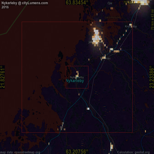
Analysis of Nykarleby night lights 2016
Square area 10x10 km:
 0%
0%90-99
0%80-89
0.47%70-79
0.28%60-69
0.38%50-59
0.66%40-49
0.47%30-39
0.38%20-29
0%10-19
0%0-9
97.35%Square area 50x50 km:
0.18%90-99
0.34%80-89
0.18%70-79
0.18%60-69
0.23%50-59
0.31%40-49
0.17%30-39
0.15%20-29
0.28%10-19
1.47%0-9
96.51%Clear (daylight) street map image can be seen on geolist.org.
Map coordinates:
63° 50' 4.3" North, 21° 49' 39.4" East
63° 31' 22" North, 22° 31' 50.6" East
63° 12' 27.2" North, 23° 14' 1.9" East
Some cities around Nykarleby sort by population:
• Kokkola
45.9 km =28.5 mi,  40°
40°
• Jakobstad
18.9 km =11.7 mi,  26°
26°
• Korsholm
62.1 km =38.6 mi,  223°
223°
• Pedersöre
16 km =9.9 mi, 28°
• Kauhava
53.9 km =33.5 mi,  149°
149°
• Kronoby
33.8 km =21 mi,  47°
47°
• Ylistaro
64.9 km =40.3 mi,  180°
180°
• Isokyrö
57.7 km =35.9 mi,  189°
189°
644100 (p: 7,338)
Sources (retrieved 2019-11-25):
» Earth at Night: Flat Maps 2012, 2016