Paimio night lights from space
Night Light of Paimio (Southwest Finland) from space (Finland) Src. Average luminocity for 10x10km area is 7.5517% and for 50x50km: 9.5102%.
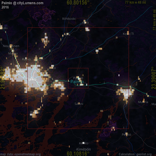
Analysis of Paimio night lights 2016
Square area 10x10 km:
 0.72%
0.72%90-99
1.45%80-89
1.96%70-79
0.72%60-69
1.24%50-59
0.93%40-49
0.41%30-39
0%20-29
0%10-19
0%0-9
92.56%Square area 50x50 km:
2.5%90-99
1.93%80-89
0.65%70-79
0.95%60-69
0.98%50-59
0.9%40-49
0.9%30-39
1.09%20-29
1.89%10-19
5.35%0-9
82.85%Clear (daylight) street map image can be seen on geolist.org.
Map coordinates:
60° 48' 5.6" North, 21° 59' 1.8" East
60° 27' 24.2" North, 22° 41' 13" East
60° 6' 29.4" North, 23° 23' 24.3" East
Some cities around Paimio sort by population:
• Turku
22.9 km =14.2 mi,  268°
268°
• Salo
25.8 km =16 mi,  108°
108°
• Kaarina
18.3 km =11.4 mi,  252°
252°
• Väståboland
27.5 km =17.1 mi,  230°
230°
• Lieto
13.7 km =8.5 mi,  295°
295°
• Pargas
27 km =16.8 mi, 231°
• Halikko
22.6 km =14 mi, 106°
• Piikkiö
10 km =6.2 mi, 249°
643153 (p: 10,126)
Sources (retrieved 2019-11-25):
» Earth at Night: Flat Maps 2012, 2016