Masku night lights from space
Night Light of Masku (Southwest Finland) from space (Finland) Src. Average luminocity for 10x10km area is 10.9607% and for 50x50km: 11.7678%.
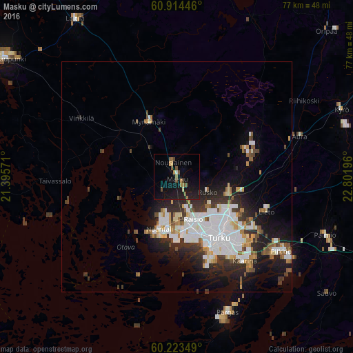
Analysis of Masku night lights 2016
Square area 10x10 km:
 0%
0%90-99
0.62%80-89
0.52%70-79
1.14%60-69
1.76%50-59
3%40-49
1.86%30-39
0.21%20-29
3.41%10-19
19.11%0-9
68.39%Square area 50x50 km:
3.18%90-99
2.71%80-89
0.81%70-79
0.92%60-69
1.11%50-59
1.01%40-49
1.2%30-39
1.62%20-29
3.04%10-19
6.46%0-9
77.95%Clear (daylight) street map image can be seen on geolist.org.
Map coordinates:
60° 54' 52.1" North, 21° 23' 44.6" East
60° 34' 15" North, 22° 5' 55.8" East
60° 13' 24.6" North, 22° 48' 7.1" East
Some cities around Masku sort by population:
• Turku
16.2 km =10.1 mi,  144°
144°
• Raisio
10.2 km =6.3 mi,  157°
157°
• Kaarina
23.4 km =14.5 mi, 140°
• Lieto
21 km =13 mi,  108°
108°
• Naantali
12.2 km =7.6 mi,  199°
199°
• Pargas
31.4 km =19.5 mi, 159°
• Piikkiö
28 km =17.4 mi,  125°
125°
• Mynämäki
13.4 km =8.3 mi,  334°
334°
646486 (p: 5,974)
Sources (retrieved 2019-11-25):
» Earth at Night: Flat Maps 2012, 2016