Villamartín night lights from space
Night Light of Villamartín (Andalusia) from space (Spain) Src. Average luminocity for 10x10km area is 6.0016% and for 50x50km: 2.93%.
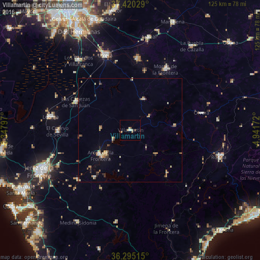
Analysis of Villamartín night lights 2016
Square area 10x10 km:
 0.81%
0.81%90-99
0.49%80-89
1.95%70-79
0.65%60-69
0.65%50-59
0.97%40-49
0.32%30-39
0.65%20-29
0%10-19
0.65%0-9
92.86%Square area 50x50 km:
0.18%90-99
0.3%80-89
0.58%70-79
0.5%60-69
0.41%50-59
0.38%40-49
0.29%30-39
0.5%20-29
0.43%10-19
0.68%0-9
95.74%Clear (daylight) street map image can be seen on geolist.org.
Map coordinates:
37° 25' 13" North, 6° 20' 52.7" West
36° 51' 35.2" North, 5° 38' 41.5" West
36° 17' 42.5" North, 4° 56' 30.2" West
Some cities around Villamartín sort by population:
• Arcos de la Frontera
19.1 km =11.9 mi,  230°
230°
• Ubrique
26.9 km =16.7 mi,  138°
138°
• Bornos
10.1 km =6.3 mi,  241°
241°
• Montellano
16.4 km =10.2 mi,  23°
23°
• Puerto Serrano
11.4 km =7.1 mi,  52°
52°
• Prado del Rey
11.3 km =7 mi, 135°
• Algodonales
21.4 km =13.3 mi,  83°
83°
• El Coronil
24.5 km =15.2 mi,  2°
2°
2509575 (p: 12,526)
Sources (retrieved 2019-11-25):
» Earth at Night: Flat Maps 2012, 2016