Bornos night lights from space
Night Light of Bornos (Andalusia) from space (Spain) Src. Average luminocity for 10x10km area is 5.6477% and for 50x50km: 3.4766%.
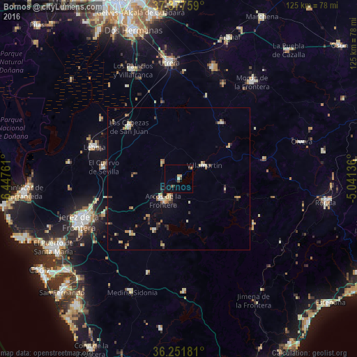
Analysis of Bornos night lights 2016
Square area 10x10 km:
 0%
0%90-99
0.16%80-89
0.49%70-79
1.79%60-69
0.16%50-59
0.65%40-49
0.97%30-39
1.14%20-29
0.49%10-19
2.92%0-9
91.23%Square area 50x50 km:
0.23%90-99
0.29%80-89
0.75%70-79
0.53%60-69
0.45%50-59
0.32%40-49
0.4%30-39
0.61%20-29
0.49%10-19
0.74%0-9
95.19%Clear (daylight) street map image can be seen on geolist.org.
Map coordinates:
37° 22' 39.3" North, 6° 26' 51.4" West
36° 49' 0.4" North, 5° 44' 40.1" West
36° 15' 6.5" North, 5° 2' 28.9" West
Some cities around Bornos sort by population:
• Arcos de la Frontera
9.4 km =5.8 mi,  218°
218°
• Las Cabezas de San Juan
25.4 km =15.8 mi,  316°
316°
• Villamartín
10.1 km =6.3 mi,  61°
61°
• El Cuervo
26.4 km =16.4 mi,  278°
278°
• Montellano
25.1 km =15.6 mi,  37°
37°
• Puerto Serrano
21.4 km =13.3 mi, 56°
• Prado del Rey
17.1 km =10.6 mi,  100°
100°
• El Coronil
30.8 km =19.1 mi,  18°
18°
2520832 (p: 8,105)
Sources (retrieved 2019-11-25):
» Earth at Night: Flat Maps 2012, 2016