Tomiño night lights from space
Night Light of Tomiño (Galicia) from space (Spain) Src. Average luminocity for 10x10km area is 21.9524% and for 50x50km: 17.8302%.
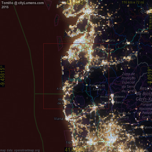
Analysis of Tomiño night lights 2016
Square area 10x10 km:
 0.48%
0.48%90-99
1.75%80-89
0.63%70-79
3.02%60-69
1.9%50-59
4.92%40-49
7.94%30-39
3.49%20-29
7.3%10-19
39.52%0-9
29.05%Square area 50x50 km:
1.32%90-99
2.95%80-89
2.22%70-79
2.23%60-69
2.69%50-59
2.81%40-49
3.09%30-39
2.78%20-29
6.47%10-19
14.29%0-9
59.15%Clear (daylight) street map image can be seen on geolist.org.
Map coordinates:
42° 30' 29.5" North, 9° 27' 29.3" West
41° 59' 15.8" North, 8° 45' 18.1" West
41° 27' 46.6" North, 8° 3' 6.8" West
Some cities around Tomiño sort by population:
• Nigrán
17.6 km =10.9 mi,  346°
346°
• Porriño
22.3 km =13.9 mi,  30°
30°
• Tui
11.3 km =7 mi,  54°
54°
• Valenza, PT
10.7 km =6.6 mi,  67°
67°
• Gondomar
13.8 km =8.6 mi,  1°
1°
• Baiona
16.3 km =10.1 mi,  331°
331°
• Salvatierra de Miño
23.6 km =14.7 mi,  63°
63°
• O Rosal
8.9 km =5.5 mi,  229°
229°
3108000 (p: 13,315)
Sources (retrieved 2019-11-25):
» Earth at Night: Flat Maps 2012, 2016