Tineo night lights from space
Night Light of Tineo (Asturias) from space (Spain) Src. Average luminocity for 10x10km area is 2.027% and for 50x50km: 1.2571%.
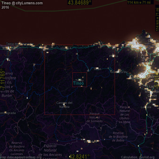
Analysis of Tineo night lights 2016
Square area 10x10 km:
 0%
0%90-99
0%80-89
0%70-79
1.11%60-69
0.48%50-59
0.63%40-49
0%30-39
0%20-29
0.95%10-19
0%0-9
96.83%Square area 50x50 km:
0.03%90-99
0.13%80-89
0.17%70-79
0.22%60-69
0.16%50-59
0.11%40-49
0.24%30-39
0.35%20-29
0.57%10-19
0.28%0-9
97.73%Clear (daylight) street map image can be seen on geolist.org.
Map coordinates:
43° 50' 48.8" North, 7° 7' 3.5" West
43° 20' 15.5" North, 6° 24' 52.3" West
42° 49' 26.8" North, 5° 42' 41" West
Some cities around Tineo sort by population:
• Cangas del Narcea
20.4 km =12.7 mi,  212°
212°
• Llanera
41.4 km =25.7 mi,  70°
70°
• Grado
28.1 km =17.5 mi,  78°
78°
• Villablino
45 km =28 mi,  170°
170°
• Piedras Blancas
43.1 km =26.8 mi,  55°
55°
• Navia
33 km =20.5 mi,  311°
311°
• Salas
14.9 km =9.3 mi, 56°
• Cudillero
33.1 km =20.6 mi,  40°
40°
3108087 (p: 11,146)
Sources (retrieved 2019-11-25):
» Earth at Night: Flat Maps 2012, 2016