Tafalla night lights from space
Night Light of Tafalla (Navarre) from space (Spain) Src. Average luminocity for 10x10km area is 11.6143% and for 50x50km: 5.24%.
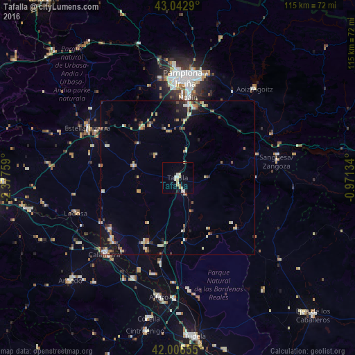
Analysis of Tafalla night lights 2016
Square area 10x10 km:
 1.9%
1.9%90-99
2.38%80-89
1.75%70-79
2.54%60-69
0.63%50-59
0%40-49
0%30-39
0.32%20-29
1.11%10-19
2.22%0-9
87.14%Square area 50x50 km:
0.44%90-99
0.77%80-89
0.87%70-79
0.68%60-69
0.8%50-59
0.5%40-49
0.54%30-39
0.52%20-29
0.89%10-19
2.71%0-9
91.27%Clear (daylight) street map image can be seen on geolist.org.
Map coordinates:
43° 2' 34.4" North, 2° 22' 39.3" West
42° 31' 36.7" North, 1° 40' 28.1" West
42° 0' 23.6" North, 0° 58' 16.8" West
Some cities around Tafalla sort by population:
• Iturrama
31.3 km =19.4 mi,  2°
2°
• Primer Ensanche
32.1 km =19.9 mi, 3°
• Segundo Ensanche
32 km =19.9 mi, 4°
• Barañáin
31 km =19.3 mi,  359°
359°
• Ermitagaña
31.6 km =19.6 mi, 1°
• Cizur Mayor
29.1 km =18.1 mi, 357°
• San Adrián
30.3 km =18.8 mi,  224°
224°
• Peralta
23.4 km =14.5 mi,  206°
206°
3108412 (p: 11,394)
Sources (retrieved 2019-11-25):
» Earth at Night: Flat Maps 2012, 2016