Súria night lights from space
Night Light of Súria (Catalonia) from space (Spain) Src. Average luminocity for 10x10km area is 8.7968% and for 50x50km: 7.2466%.
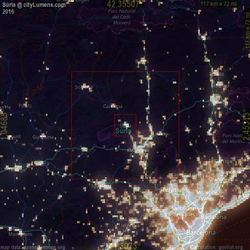
Analysis of Súria night lights 2016
Square area 10x10 km:
 1.43%
1.43%90-99
1.11%80-89
0.79%70-79
0.48%60-69
0.63%50-59
0.16%40-49
2.38%30-39
0.63%20-29
1.27%10-19
5.71%0-9
85.4%Square area 50x50 km:
0.61%90-99
0.99%80-89
1.03%70-79
0.83%60-69
0.85%50-59
0.77%40-49
0.84%30-39
1.12%20-29
2.53%10-19
6.36%0-9
84.05%Clear (daylight) street map image can be seen on geolist.org.
Map coordinates:
42° 21' 18.3" North, 1° 2' 48.8" East
41° 49' 60" North, 1° 45' 0" East
41° 18' 26.3" North, 2° 27' 11.3" East
Some cities around Súria sort by population:
• Manresa
13.2 km =8.2 mi,  152°
152°
• Sant Joan de Vilatorrada
10.8 km =6.7 mi,  155°
155°
• Solsona
26.3 km =16.3 mi,  312°
312°
• Sant Vicenç de Castellet
20.9 km =13 mi, 152°
• Sallent
12.1 km =7.5 mi,  93°
93°
• Navàs
12.9 km =8 mi,  54°
54°
• Navarcles
15.6 km =9.7 mi,  125°
125°
• Cardona
10.7 km =6.6 mi,  326°
326°
3108487 (p: 6,230)
Sources (retrieved 2019-11-25):
» Earth at Night: Flat Maps 2012, 2016