Sant Vicenç de Castellet night lights from space
Night Light of Sant Vicenç de Castellet (Catalonia) from space (Spain) Src. Average luminocity for 10x10km area is 25.8718% and for 50x50km: 26.4123%.
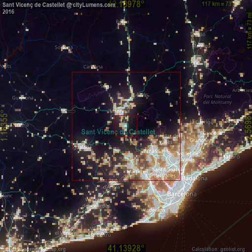
Analysis of Sant Vicenç de Castellet night lights 2016
Square area 10x10 km:
 1.62%
1.62%90-99
0.97%80-89
4.87%70-79
5.19%60-69
2.76%50-59
2.76%40-49
2.44%30-39
3.41%20-29
11.53%10-19
42.53%0-9
21.92%Square area 50x50 km:
4.42%90-99
5.38%80-89
3.22%70-79
3.63%60-69
4.17%50-59
3.38%40-49
2.47%30-39
2.91%20-29
7.43%10-19
13.88%0-9
49.11%Clear (daylight) street map image can be seen on geolist.org.
Map coordinates:
42° 11' 23.2" North, 1° 9' 48.8" East
41° 40' 0" North, 1° 52' 0" East
41° 8' 21.4" North, 2° 34' 11.3" East
Some cities around Sant Vicenç de Castellet sort by population:
• Terrassa
16.7 km =10.4 mi,  131°
131°
• Manresa
7.7 km =4.8 mi,  332°
332°
• Olesa de Montserrat
13.9 km =8.6 mi,  170°
170°
• Esparreguera
14.3 km =8.9 mi,  178°
178°
• Abrera
16.9 km =10.5 mi, 170°
• Matadepera
15.3 km =9.5 mi,  119°
119°
• Sallent
17.9 km =11.1 mi,  7°
7°
• Navarcles
9.9 km =6.2 mi,  17°
17°
3109451 (p: 8,096)
Sources (retrieved 2019-11-25):
» Earth at Night: Flat Maps 2012, 2016