Sant Genís dels Agudells night lights from space
Night Light of Sant Genís dels Agudells (Catalonia) from space (Spain) Src. Average luminocity for 10x10km area is 85.8197% and for 50x50km: 45.8043%.
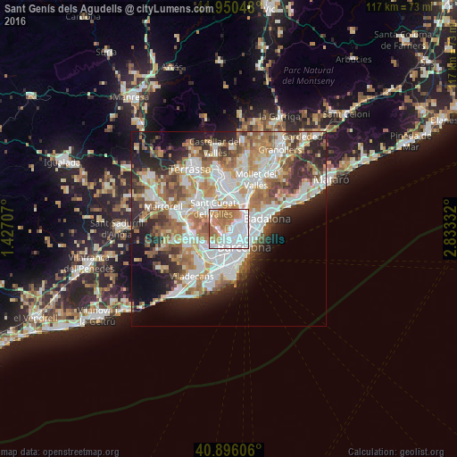
Analysis of Sant Genís dels Agudells night lights 2016
Square area 10x10 km:
 36.39%
90-99
20.41%80-89
3.74%70-79
11.39%60-69
25.17%50-59
2.89%40-49
0%30-39
0%20-29
0%10-19
0%0-9
0%Square area 50x50 km:
11.79%90-99
10.69%80-89
4.45%70-79
5.49%60-69
8.31%50-59
6.2%40-49
3.97%30-39
4.45%20-29
8.34%10-19
8.87%0-9
27.45%Clear (daylight) street map image can be seen on geolist.org.
Map coordinates:
41° 57' 1.7" North, 1° 25' 37.5" East
41° 25' 31.5" North, 2° 7' 48.7" East
40° 53' 45.8" North, 2° 49' 60" East
Some cities around Sant Genís dels Agudells sort by population:
• el Putxet i el Farró
2.4 km =1.5 mi,  150°
150°
• La Bonanova
2.2 km =1.4 mi,  175°
175°
• Vallcarca
1.9 km =1.2 mi,  142°
142°
• la Salut
2.5 km =1.6 mi,  125°
125°
• la Teixonera
1.4 km =0.9 mi,  100°
100°
• el Coll
1.7 km =1.1 mi,  122°
122°
• la Vall d'Hebron
1.6 km =1 mi,  69°
69°
• Montbau
1.3 km =0.8 mi,  30°
30°
11549769 (p: 6,891)
Sources (retrieved 2019-11-25):
» Earth at Night: Flat Maps 2012, 2016