Sangüesa/Zangoza night lights from space
Night Light of Sangüesa/Zangoza (Navarre) from space (Spain) Src. Average luminocity for 10x10km area is 5.827% and for 50x50km: 1.6294%.
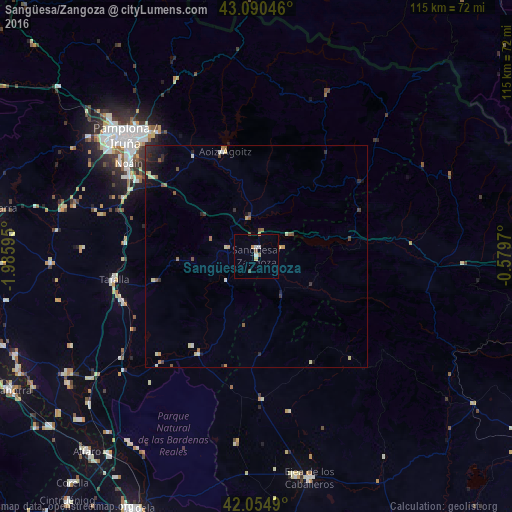
Analysis of Sangüesa/Zangoza night lights 2016
Square area 10x10 km:
 1.27%
1.27%90-99
0.63%80-89
0.63%70-79
0.48%60-69
1.11%50-59
0.63%40-49
0.48%30-39
0.48%20-29
0%10-19
0%0-9
94.29%Square area 50x50 km:
0.11%90-99
0.19%80-89
0.31%70-79
0.18%60-69
0.25%50-59
0.24%40-49
0.22%30-39
0.21%20-29
0.48%10-19
0.7%0-9
97.12%Clear (daylight) street map image can be seen on geolist.org.
Map coordinates:
43° 5' 25.7" North, 1° 59' 9.4" West
42° 34' 29.4" North, 1° 16' 58.2" West
42° 3' 17.6" North, 0° 34' 46.9" West
Some cities around Sangüesa/Zangoza sort by population:
• Pamplona
39.9 km =24.8 mi,  312°
312°
• Iturrama
40.2 km =25 mi, 310°
• Primer Ensanche
40.1 km =24.9 mi, 311°
• Segundo Ensanche
39.7 km =24.7 mi, 312°
• Burlata
39 km =24.2 mi,  315°
315°
• Sarriguren
36.9 km =22.9 mi, 315°
• Tafalla
32.5 km =20.2 mi,  260°
260°
• Atarrabia
39 km =24.2 mi, 317°
3110589 (p: 5,030)
Sources (retrieved 2019-11-25):
» Earth at Night: Flat Maps 2012, 2016