Rota night lights from space
Night Light of Rota (Andalusia) from space (Spain) Src. Average luminocity for 10x10km area is 31.4048% and for 50x50km: 15.4889%.
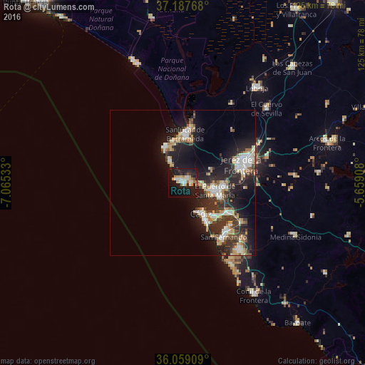

Analysis of Rota night lights 2016
Square area 10x10 km:
 4.58%
4.58%90-99
6.96%80-89
3.11%70-79
4.95%60-69
4.58%50-59
0.73%40-49
0.73%30-39
3.11%20-29
6.41%10-19
46.52%0-9
18.32%Square area 50x50 km:
2.68%90-99
2.45%80-89
1.69%70-79
1.88%60-69
2.06%50-59
0.82%40-49
1.95%30-39
3.4%20-29
5.48%10-19
12.6%0-9
64.97%Clear (daylight) street map image can be seen on geolist.org.
Map coordinates:
37° 11' 15.6" North, 7° 3' 55.2" West
36° 37' 31.6" North, 6° 21' 43.9" West
36° 3' 32.7" North, 5° 39' 32.7" West
Some cities around Rota sort by population:
• Jerez de la Frontera
21.3 km =13.2 mi,  71°
71°
• Cadiz
12.8 km =8 mi,  149°
149°
• San Fernando
22.2 km =13.8 mi,  138°
138°
• El Puerto de Santa María
12.1 km =7.5 mi,  106°
106°
• Chiclana de la Frontera
30.1 km =18.7 mi, 139°
• Sanlúcar de Barrameda
17 km =10.6 mi,  3°
3°
• Puerto Real
18.8 km =11.7 mi,  125°
125°
• Chipiona
14 km =8.7 mi,  331°
331°
2511700 (p: 29,179)
Sources (retrieved 2019-11-25):
» Earth at Night: Flat Maps 2012, 2016