Pozoblanco night lights from space
Night Light of Pozoblanco (Andalusia) from space (Spain) Src. Average luminocity for 10x10km area is 10.0765% and for 50x50km: 1.1792%.
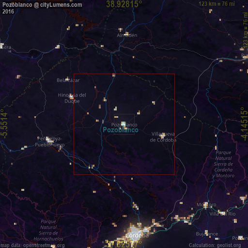
Analysis of Pozoblanco night lights 2016
Square area 10x10 km:
 1.19%
1.19%90-99
2.21%80-89
1.87%70-79
1.7%60-69
1.19%50-59
0.68%40-49
0%30-39
1.19%20-29
0.17%10-19
0.68%0-9
89.12%Square area 50x50 km:
0.06%90-99
0.23%80-89
0.21%70-79
0.17%60-69
0.2%50-59
0.23%40-49
0.15%30-39
0.13%20-29
0.08%10-19
0.07%0-9
98.48%Clear (daylight) street map image can be seen on geolist.org.
Map coordinates:
38° 55' 41.3" North, 5° 33' 5" West
38° 22' 44.6" North, 4° 50' 53.8" West
37° 49' 32.8" North, 4° 8' 42.5" West
Some cities around Pozoblanco sort by population:
• Córdoba
54.6 km =33.9 mi,  173°
173°
• Peñarroya-Pueblonuevo
37.5 km =23.3 mi,  256°
256°
• Villanueva de Córdoba
20.1 km =12.5 mi,  108°
108°
• Montoro
56.6 km =35.2 mi,  134°
134°
• Hinojosa del Duque
29.3 km =18.2 mi,  297°
297°
• Almodóvar del Río
65 km =40.4 mi,  193°
193°
• Cabeza del Buey
50 km =31.1 mi,  319°
319°
• Fuente Obejuna
51.1 km =31.8 mi, 255°
2512340 (p: 17,669)
Sources (retrieved 2019-11-25):
» Earth at Night: Flat Maps 2012, 2016