Mojacar night lights from space
Night Light of Mojacar (Andalusia) from space (Spain) Src. Average luminocity for 10x10km area is 16.1276% and for 50x50km: 4.2753%.
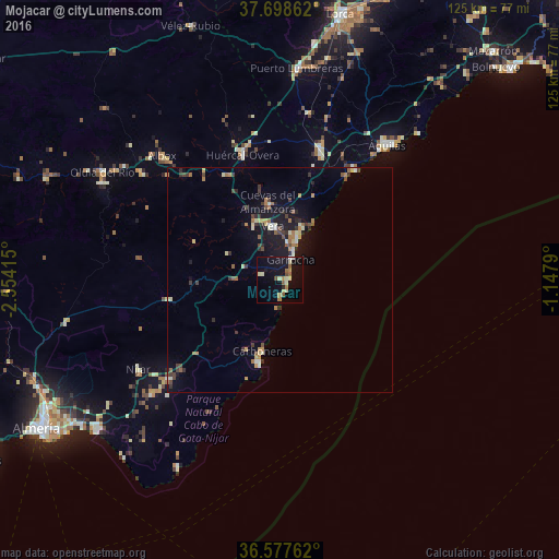
Analysis of Mojacar night lights 2016
Square area 10x10 km:
 0.34%
0.34%90-99
3.06%80-89
2.72%70-79
1.7%60-69
3.06%50-59
2.72%40-49
1.36%30-39
0.17%20-29
0.51%10-19
14.97%0-9
69.39%Square area 50x50 km:
0.24%90-99
0.55%80-89
0.54%70-79
0.47%60-69
0.71%50-59
0.56%40-49
0.65%30-39
0.76%20-29
0.63%10-19
3.38%0-9
91.51%Clear (daylight) street map image can be seen on geolist.org.
Map coordinates:
37° 41' 55" North, 2° 33' 14.9" West
37° 8' 24.7" North, 1° 51' 3.7" West
36° 34' 39.4" North, 1° 8' 52.4" West
Some cities around Mojacar sort by population:
• Águilas
37.9 km =23.5 mi,  38°
38°
• Níjar
36.9 km =22.9 mi,  238°
238°
• Huércal-Overa
28.9 km =18 mi,  343°
343°
• Vera
11.5 km =7.1 mi,  356°
356°
• Cuevas del Almanzora
17.6 km =10.9 mi,  350°
350°
• Pulpí
31.6 km =19.6 mi,  17°
17°
• Carboneras
16.5 km =10.3 mi,  194°
194°
• Garrucha
5.2 km =3.2 mi,  28°
28°
2513786 (p: 5,154)
Sources (retrieved 2019-11-25):
» Earth at Night: Flat Maps 2012, 2016