Los Santos de Maimona night lights from space
Night Light of Los Santos de Maimona (Extremadura) from space (Spain) Src. Average luminocity for 10x10km area is 14.5422% and for 50x50km: 2.5399%.
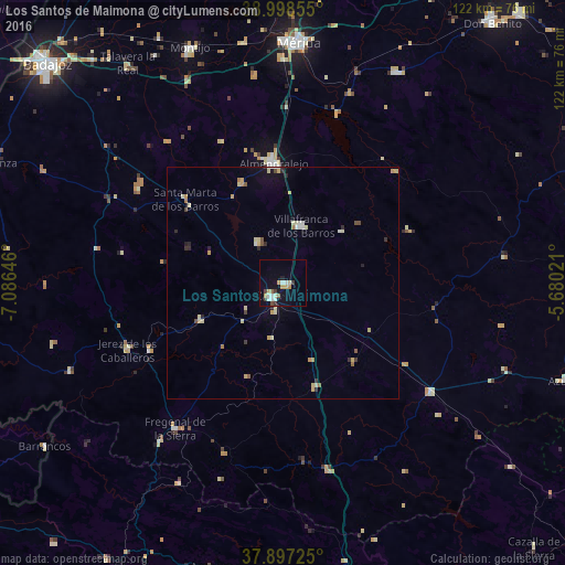
Analysis of Los Santos de Maimona night lights 2016
Square area 10x10 km:
 2.76%
2.76%90-99
1.95%80-89
1.62%70-79
3.25%60-69
0.16%50-59
1.3%40-49
1.3%30-39
2.6%20-29
0.16%10-19
6.33%0-9
78.57%Square area 50x50 km:
0.21%90-99
0.28%80-89
0.68%70-79
0.48%60-69
0.13%50-59
0.2%40-49
0.21%30-39
0.32%20-29
0.34%10-19
0.64%0-9
96.51%Clear (daylight) street map image can be seen on geolist.org.
Map coordinates:
38° 59' 54.8" North, 7° 5' 11.3" West
38° 27' 0" North, 6° 22' 60" West
37° 53' 50.1" North, 5° 40' 48.8" West
Some cities around Los Santos de Maimona sort by population:
• Almendralejo
26 km =16.2 mi,  355°
355°
• Zafra
4 km =2.5 mi,  227°
227°
• Villafranca de los Barros
13 km =8.1 mi,  17°
17°
• Jerez de los Caballeros
36.9 km =22.9 mi,  247°
247°
• Fuente del Maestre
10.2 km =6.3 mi,  326°
326°
• Llerena
40 km =24.9 mi,  126°
126°
• Aceuchal
23.6 km =14.7 mi,  337°
337°
• Fregenal de la Sierra
39.1 km =24.3 mi,  217°
217°
2514460 (p: 7,937)
Sources (retrieved 2019-11-25):
» Earth at Night: Flat Maps 2012, 2016