El Molar night lights from space
Night Light of El Molar (Madrid) from space (Spain) Src. Average luminocity for 10x10km area is 16.2581% and for 50x50km: 18.7514%.
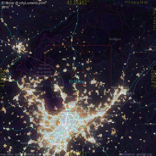
Analysis of El Molar night lights 2016
Square area 10x10 km:
 1.14%
1.14%90-99
2.44%80-89
1.95%70-79
1.14%60-69
2.6%50-59
0.16%40-49
2.92%30-39
1.46%20-29
1.3%10-19
15.1%0-9
69.81%Square area 50x50 km:
2.07%90-99
3.38%80-89
1.75%70-79
2.07%60-69
2.57%50-59
2.43%40-49
2.65%30-39
3.6%20-29
6.46%10-19
14.03%0-9
58.99%Clear (daylight) street map image can be seen on geolist.org.
Map coordinates:
41° 15' 46.2" North, 4° 16' 58.2" West
40° 43' 55.7" North, 3° 34' 46.9" West
40° 11' 50" North, 2° 52' 35.7" West
Some cities around El Molar sort by population:
• Alcobendas
21.2 km =13.2 mi,  194°
194°
• San Sebastián de los Reyes
20 km =12.4 mi, 191°
• Colmenar Viejo
17.8 km =11.1 mi,  242°
242°
• Tres Cantos
18.2 km =11.3 mi,  216°
216°
• Algete
16.5 km =10.3 mi,  155°
155°
• San Agustín del Guadalix
6.7 km =4.2 mi,  207°
207°
• Fuente el Saz
12.5 km =7.8 mi,  152°
152°
• Miraflores de la Sierra
17.9 km =11.1 mi,  301°
301°
3123421 (p: 5,051)
Sources (retrieved 2019-11-25):
» Earth at Night: Flat Maps 2012, 2016