Deltebre night lights from space
Night Light of Deltebre (Catalonia) from space (Spain) Src. Average luminocity for 10x10km area is 13.9269% and for 50x50km: 5.5312%.
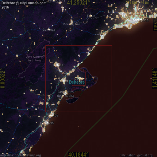
Analysis of Deltebre night lights 2016
Square area 10x10 km:
 0%
0%90-99
0.65%80-89
2.6%70-79
3.25%60-69
2.76%50-59
2.76%40-49
0.65%30-39
0%20-29
2.6%10-19
5.84%0-9
78.9%Square area 50x50 km:
0.31%90-99
0.55%80-89
0.8%70-79
0.74%60-69
0.68%50-59
1.07%40-49
0.53%30-39
0.68%20-29
0.95%10-19
4.16%0-9
89.54%Clear (daylight) street map image can be seen on geolist.org.
Map coordinates:
41° 15' 0.8" North, 0° 0' 18.8" East
40° 43' 10" North, 0° 42' 30.1" East
40° 11' 3.8" North, 1° 24' 41.3" East
Some cities around Deltebre sort by population:
• Tortosa
18.8 km =11.7 mi,  303°
303°
• Vinaròs
34 km =21.1 mi,  215°
215°
• Benicarló
41.2 km =25.6 mi, 215°
• Amposta
11 km =6.8 mi,  264°
264°
• Sant Carles de la Ràpita
14.6 km =9.1 mi, 218°
• Mont-roig del Camp
46 km =28.6 mi,  27°
27°
• Alcanar
27.4 km =17 mi, 224°
• Ulldecona
25.9 km =16.1 mi,  238°
238°
6559504 (p: 11,751)
Sources (retrieved 2019-11-25):
» Earth at Night: Flat Maps 2012, 2016