Amurrio night lights from space
Night Light of Amurrio (Basque Country) from space (Spain) Src. Average luminocity for 10x10km area is 13.4746% and for 50x50km: 10.8965%.
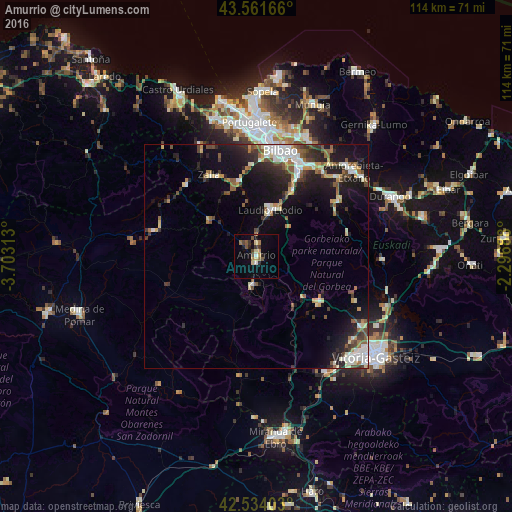
Analysis of Amurrio night lights 2016
Square area 10x10 km:
 0.48%
0.48%90-99
0.79%80-89
2.54%70-79
1.59%60-69
2.54%50-59
2.38%40-49
2.06%30-39
2.38%20-29
1.59%10-19
3.65%0-9
80%Square area 50x50 km:
1.54%90-99
1.77%80-89
1.18%70-79
0.95%60-69
1.34%50-59
1.81%40-49
1.36%30-39
1.61%20-29
3.35%10-19
8.08%0-9
77.01%Clear (daylight) street map image can be seen on geolist.org.
Map coordinates:
43° 33' 42" North, 3° 42' 11.3" West
43° 3' 0" North, 3° 0' 0" West
42° 32' 2.5" North, 2° 17' 48.8" West
Some cities around Amurrio sort by population:
• Bilbao
24.4 km =15.2 mi,  14°
14°
• Santutxu
23.6 km =14.7 mi,  16°
16°
• Basauri
23 km =14.3 mi, 23°
• Galdakao
23.8 km =14.8 mi,  32°
32°
• Laudio / Llodio
10.8 km =6.7 mi, 16°
• Arrigorriaga
20.1 km =12.5 mi, 27°
• Zalla
23.1 km =14.4 mi,  332°
332°
• Güeñes
19.6 km =12.2 mi,  336°
336°
3130124 (p: 10,089)
Sources (retrieved 2019-11-25):
» Earth at Night: Flat Maps 2012, 2016