Sønderborg night lights from space
Night Light of Sønderborg (South Denmark) from space (Denmark) Src. Average luminocity for 10x10km area is 11.4928% and for 50x50km: 2.5905%.
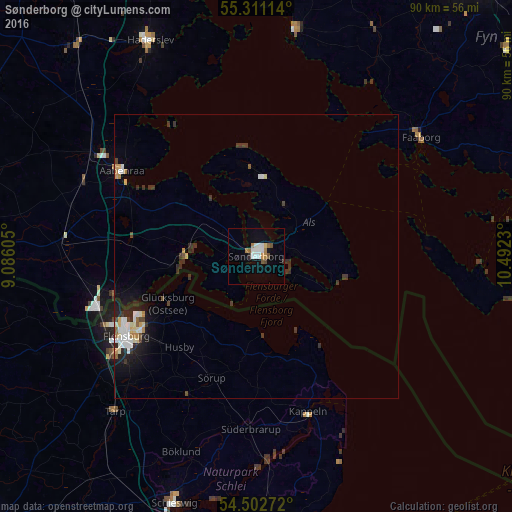
Analysis of Sønderborg night lights 2016
Square area 10x10 km:
 2.39%
2.39%90-99
2.39%80-89
0.48%70-79
0.6%60-69
1.79%50-59
1.67%40-49
1.2%30-39
0%20-29
0.96%10-19
2.87%0-9
85.65%Square area 50x50 km:
0.45%90-99
0.54%80-89
0.22%70-79
0.17%60-69
0.26%50-59
0.19%40-49
0.26%30-39
0.62%20-29
0.69%10-19
1.38%0-9
95.21%Clear (daylight) street map image can be seen on geolist.org.
Map coordinates:
55° 18' 40.1" North, 9° 5' 9.8" East
54° 54' 32.3" North, 9° 47' 21" East
54° 30' 9.8" North, 10° 29' 32.3" East
Some cities around Sønderborg sort by population:
• Flensburg, DE
26.3 km =16.3 mi,  238°
238°
• Aabenraa
28.1 km =17.5 mi,  302°
302°
• Harrislee, DE
28.7 km =17.8 mi, 244°
• Kappeln, DE
29 km =18 mi,  161°
161°
• Nordborg
16.8 km =10.4 mi,  349°
349°
• Handewitt, DE
33.2 km =20.6 mi, 241°
• Glücksburg, DE
17.4 km =10.8 mi, 241°
• Rødekro
34.1 km =21.2 mi, 301°
2613102 (p: 27,033)
Sources (retrieved 2019-11-25):
» Earth at Night: Flat Maps 2012, 2016