Ebeltoft night lights from space
Night Light of Ebeltoft (Central Jutland) from space (Denmark) Src. Average luminocity for 10x10km area is 2.6376% and for 50x50km: 0.7598%.
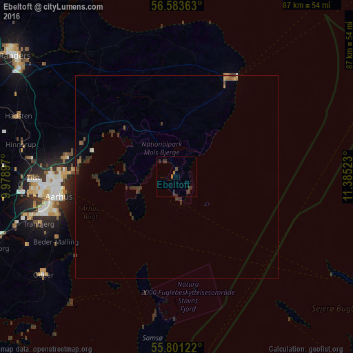
Analysis of Ebeltoft night lights 2016
Square area 10x10 km:
 0%
0%90-99
0%80-89
0%70-79
0%60-69
0.96%50-59
0%40-49
0.48%30-39
3.83%20-29
0.96%10-19
0%0-9
93.78%Square area 50x50 km:
0.01%90-99
0.02%80-89
0.05%70-79
0.04%60-69
0.18%50-59
0.08%40-49
0.09%30-39
0.75%20-29
0.25%10-19
0.05%0-9
98.47%Clear (daylight) street map image can be seen on geolist.org.
Map coordinates:
56° 35' 1.1" North, 9° 58' 44.3" East
56° 11' 39.9" North, 10° 40' 55.6" East
55° 48' 4.4" North, 11° 23' 6.8" East
Some cities around Ebeltoft sort by population:
• Århus
29.5 km =18.3 mi,  261°
261°
• Grenaa
27.4 km =17 mi,  26°
26°
• Odder
41 km =25.5 mi,  233°
233°
• Lystrup
27.9 km =17.3 mi,  279°
279°
• Tranbjerg
35.6 km =22.1 mi,  251°
251°
• Hinnerup
39.1 km =24.3 mi, 281°
• Kolt
39.1 km =24.3 mi, 255°
• Løgten
24.6 km =15.3 mi,  291°
291°
2622793 (p: 7,501)
Sources (retrieved 2019-11-25):
» Earth at Night: Flat Maps 2012, 2016