Lystrup night lights from space
Night Light of Lystrup (Central Jutland) from space (Denmark) Src. Average luminocity for 10x10km area is 25.2428% and for 50x50km: 6.7492%.
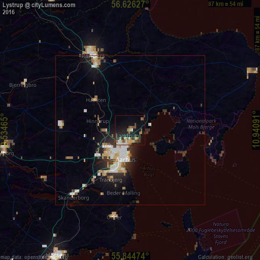
Analysis of Lystrup night lights 2016
Square area 10x10 km:
 2.27%
2.27%90-99
3.35%80-89
3.83%70-79
2.75%60-69
3.83%50-59
2.87%40-49
5.62%30-39
2.87%20-29
10.77%10-19
17.58%0-9
44.26%Square area 50x50 km:
1.08%90-99
1.29%80-89
0.81%70-79
0.63%60-69
0.74%50-59
0.83%40-49
0.69%30-39
1.07%20-29
1.98%10-19
3.93%0-9
86.93%Clear (daylight) street map image can be seen on geolist.org.
Map coordinates:
56° 37' 34.6" North, 9° 32' 4.7" East
56° 14' 15" North, 10° 14' 16" East
55° 50' 41.1" North, 10° 56' 27.3" East
Some cities around Lystrup sort by population:
• Århus
9.1 km =5.7 mi,  190°
190°
• Tranbjerg
17 km =10.6 mi,  201°
201°
• Hinnerup
11.3 km =7 mi,  286°
286°
• Hadsten
15.4 km =9.6 mi,  310°
310°
• Hammel
23.3 km =14.5 mi,  275°
275°
• Hørning
20.8 km =12.9 mi,  216°
216°
• Kolt
17.7 km =11 mi, 215°
• Løgten
6.2 km =3.9 mi,  47°
47°
2617176 (p: 9,107)
Sources (retrieved 2019-11-25):
» Earth at Night: Flat Maps 2012, 2016