Wölfersheim night lights from space
Night Light of Wölfersheim (Hesse) from space (Germany) Src. Average luminocity for 10x10km area is 2.9706% and for 50x50km: 7.5549%.
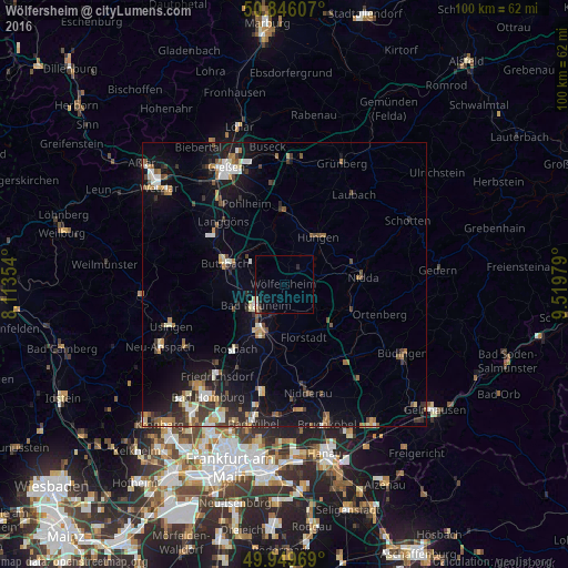
Analysis of Wölfersheim night lights 2016
Square area 10x10 km:
 0.14%
0.14%90-99
0.98%80-89
0.56%70-79
0%60-69
0%50-59
0%40-49
0.56%30-39
0%20-29
1.12%10-19
0.28%0-9
96.36%Square area 50x50 km:
0.89%90-99
1.08%80-89
0.78%70-79
0.76%60-69
1.07%50-59
0.85%40-49
1.15%30-39
1.3%20-29
1.83%10-19
5.73%0-9
84.56%Clear (daylight) street map image can be seen on geolist.org.
Map coordinates:
50° 50' 45.9" North, 8° 6' 48.7" East
50° 24' 0" North, 8° 49' 0" East
49° 56' 58.9" North, 9° 31' 11.2" East
Some cities around Wölfersheim sort by population:
• Bad Nauheim
6.8 km =4.2 mi,  234°
234°
• Friedberg
8.2 km =5.1 mi,  211°
211°
• Butzbach
11 km =6.8 mi,  290°
290°
• Florstadt
9.9 km =6.2 mi,  159°
159°
• Reichelsheim
6.3 km =3.9 mi,  139°
139°
• Ober-Mörlen
9.4 km =5.8 mi,  251°
251°
• Echzell
5.1 km =3.2 mi,  104°
104°
• Münzenberg
6.7 km =4.2 mi,  333°
333°
2806852 (p: 9,610)
Sources (retrieved 2019-11-25):
» Earth at Night: Flat Maps 2012, 2016