Wolfach night lights from space
Night Light of Wolfach (Baden-Württemberg) from space (Germany) Src. Average luminocity for 10x10km area is 3.3988% and for 50x50km: 4.1388%.
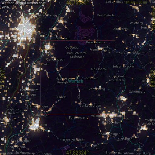
Analysis of Wolfach night lights 2016
Square area 10x10 km:
 0%
0%90-99
0%80-89
0%70-79
1.49%60-69
0.3%50-59
1.79%40-49
0.6%30-39
0.6%20-29
0.3%10-19
0.74%0-9
94.2%Square area 50x50 km:
0.41%90-99
0.39%80-89
0.31%70-79
0.36%60-69
0.59%50-59
0.76%40-49
1.01%30-39
0.88%20-29
0.83%10-19
3.37%0-9
91.08%Clear (daylight) street map image can be seen on geolist.org.
Map coordinates:
48° 45' 31.9" North, 7° 30' 45.6" East
48° 17' 35.5" North, 8° 12' 56.9" East
47° 49' 23.7" North, 8° 55' 8.1" East
Some cities around Wolfach sort by population:
• Schramberg
14.8 km =9.2 mi,  121°
121°
• Sankt Georgen im Schwarzwald
20.5 km =12.7 mi,  154°
154°
• Gengenbach
19.4 km =12.1 mi,  309°
309°
• Elzach
17.2 km =10.7 mi,  218°
218°
• Alpirsbach
14.9 km =9.3 mi,  67°
67°
• Hausach
3.1 km =1.9 mi,  251°
251°
• Seelbach
20.4 km =12.7 mi,  275°
275°
• Triberg
18 km =11.2 mi,  175°
175°
2806946 (p: 5,998)
Sources (retrieved 2019-11-25):
» Earth at Night: Flat Maps 2012, 2016