Alpirsbach night lights from space
Night Light of Alpirsbach (Baden-Württemberg) from space (Germany) Src. Average luminocity for 10x10km area is 0.1903% and for 50x50km: 2.2326%.
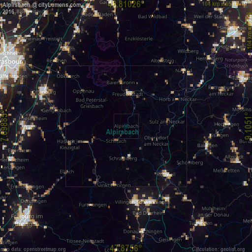
Analysis of Alpirsbach night lights 2016
Square area 10x10 km:
 0%
0%90-99
0%80-89
0%70-79
0%60-69
0%50-59
0%40-49
0%30-39
0.14%20-29
0.43%10-19
0%0-9
99.43%Square area 50x50 km:
0.11%90-99
0.2%80-89
0.22%70-79
0.35%60-69
0.26%50-59
0.43%40-49
0.53%30-39
0.45%20-29
0.53%10-19
0.7%0-9
96.22%Clear (daylight) street map image can be seen on geolist.org.
Map coordinates:
48° 48' 36.9" North, 7° 41' 55.9" East
48° 20' 42.3" North, 8° 24' 7.1" East
47° 52' 32.2" North, 9° 6' 18.4" East
Some cities around Alpirsbach sort by population:
• Freudenstadt
13.6 km =8.5 mi,  3°
3°
• Schramberg
13.5 km =8.4 mi,  185°
185°
• Oberndorf
14 km =8.7 mi,  115°
115°
• Dornstetten
15.8 km =9.8 mi,  26°
26°
• Loßburg
7.1 km =4.4 mi, 30°
• Dornhan
7.9 km =4.9 mi,  85°
85°
• Dunningen
16.6 km =10.3 mi,  152°
152°
• Wolfach
14.9 km =9.3 mi,  247°
247°
2958173 (p: 7,011)
Sources (retrieved 2019-11-25):
» Earth at Night: Flat Maps 2012, 2016