Wannweil night lights from space
Night Light of Wannweil (Baden-Württemberg) from space (Germany) Src. Average luminocity for 10x10km area is 27.9276% and for 50x50km: 14.7822%.
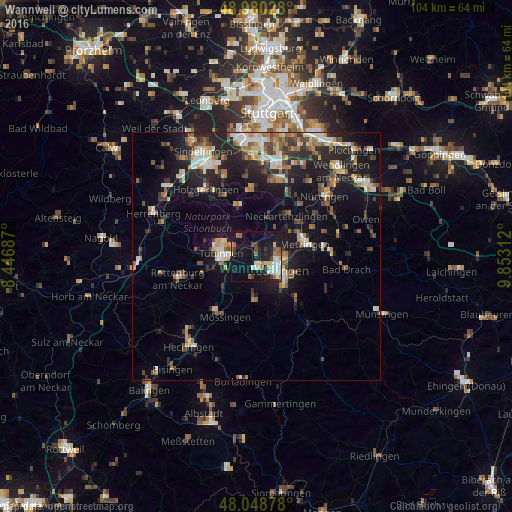
Analysis of Wannweil night lights 2016
Square area 10x10 km:
 3.98%
3.98%90-99
5.11%80-89
3.27%70-79
2.41%60-69
4.12%50-59
3.13%40-49
2.56%30-39
2.27%20-29
4.83%10-19
39.77%0-9
28.55%Square area 50x50 km:
1.62%90-99
2.16%80-89
1.52%70-79
1.68%60-69
2.12%50-59
2.07%40-49
2.11%30-39
2.23%20-29
4.95%10-19
13.32%0-9
66.23%Clear (daylight) street map image can be seen on geolist.org.
Map coordinates:
48° 58' 49" North, 8° 26' 48.7" East
48° 31' 0" North, 9° 9' 0" East
48° 2' 55.6" North, 9° 51' 11.2" East
Some cities around Wannweil sort by population:
• Reutlingen
4.9 km =3 mi,  125°
125°
• Tübingen
7.2 km =4.5 mi,  275°
275°
• Pfullingen
8.2 km =5.1 mi,  135°
135°
• Eningen unter Achalm
8.7 km =5.4 mi,  112°
112°
• Pliezhausen
6.4 km =4 mi,  41°
41°
• Gomaringen
8.1 km =5 mi,  209°
209°
• Kusterdingen
2.3 km =1.4 mi,  287°
287°
• Kirchentellinsfurt
1.8 km =1.1 mi,  353°
353°
2814195 (p: 5,092)
Sources (retrieved 2019-11-25):
» Earth at Night: Flat Maps 2012, 2016